
চিত্র:Palestine-WW1-3.jpg
এই প্রাকদর্শনের আকার: ৪১৬ × ৬০০ পিক্সেল। অন্যান্য আকারসমূহ: ১৬৬ × ২৪০ পিক্সেল | ৫৮৮ × ৮৪৮ পিক্সেল।
পূর্ণ রেজোলিউশন (৫৮৮ × ৮৪৮ পিক্সেল, ফাইলের আকার: ১০৪ কিলোবাইট, এমআইএমই ধরন: image/jpeg)
| এই ফাইলটি উইকিমিডিয়া কমন্স থেকে নেওয়া। সেখানের বর্ণনা পাতার বিস্তারিত নিম্নে দেখানো হলো। (সম্পাদনা)
|
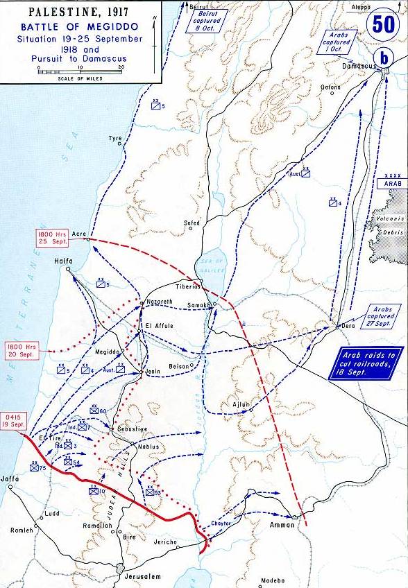
| বিবরণ | Map showing Allenby's final attack at Megiddo, September 1918. |
| তারিখ | |
| উৎস |
This map was created by the Department of Military Art and Engineering, at the U.S. Military Academy (West Point). The initial version was created under the supervision of General Vincent Esposito in 1959. It is now available on the West Point web site at: http://www.dean.usma.edu/history/web03/atlases/great%20war/great%20war%20%20pages/great%20war%20map%2050.htm The map image has been cropped to remove unneeded territory. Originally uploaded to en Wikipedia as en:Image:Palestine-WW1-3.jpg by en:User:Cglassey 25 April 2006. |
| লেখক | Department of Military Art and Engineering, at the U.S. Military Academy (West Point). |
| অনুমতি (এ ফাইলের পুনঃব্যবহার) |
US Government agency (military) - no copyright |
| অন্যান্য সংস্করণ | en:Image:Palestine-WW1-3.jpg |
এই কাজটি মার্কিন যুক্তরাষ্ট্রের পাবলিক ডোমেইনের অন্তর্গত কারণ মার্কিন যুক্তরাষ্ট্রের কোডের শিরোনাম ১৭, পরিচ্ছদ ১, অনুচ্ছেদ ১০৫ শর্তাবলীর অধীনে এটি একটি কাজ যা অফিসিয়াল দায়িত্বের অংশ হিসেবে মার্কিন যুক্তরাষ্ট্র সরকারের কর্মকর্তা বা কর্মচারী দ্বারা প্রস্তুতকৃত । বিস্তারিত জানতে দেখুন কপিরাইট।
টীকা: This only applies to original works of the Federal Government and not to the work of any individual U.S. state, territory, commonwealth, county, municipality, or any other subdivision. This template also does not apply to postage stamp designs published by the United States Postal Service since 1978. (মার্কিন যুক্তরাষ্ট্রে কপিরাইট অফিস চর্চার সারমর্মের § ৩১৩.৬(সি)(১) দেখুন)। এছাড়াও এটি নির্দিষ্ট কয়েকটি মার্কিন ধাতব মুদ্রার জন্য প্রযোজ্য নয়; মার্কিন টাকশালের ব্যবহারের শর্তাবলী দেখুন।
|
 | |
| এই ফাইলটি কপিরাইট আইনের আওতায় জানা সকল বাধানিষেধ মুক্ত বলে চিহ্নিত হয়েছে, যার মধ্যে সম্পর্কিত সকল স্বত্ব ও নেইবারিং সত্ত্ব সংযুক্ত। | ||

|
This battle map image could be re-created using vector graphics as an SVG file. This has several advantages; see Commons:Media for cleanup for more information. If an SVG form of this image is available, please upload it and afterwards replace this template with
{{vector version available|new image name}}.
It is recommended to name the SVG file “Palestine-WW1-3.svg”—then the template Vector version available (or Vva) does not need the new image name parameter. |


ফাইলের ইতিহাস
যেকোনো তারিখ/সময়ে ক্লিক করে দেখুন ফাইলটি তখন কী অবস্থায় ছিল।
| তারিখ/সময় | সংক্ষেপচিত্র | মাত্রা | ব্যবহারকারী | মন্তব্য | |
|---|---|---|---|---|---|
| বর্তমান | ০৭:০০, ২০ ফেব্রুয়ারি ২০০৮ | | ৫৮৮ × ৮৪৮ (১০৪ কিলোবাইট) | Rcbutcher | {{Information |Description=Map showing Allenby's final attack at Megiddo, September 1918. |Source=This map was created by the Department of Military Art and Engineering, at the U.S. Military Academy (West Point). The initial version was created under the |
সংযোগসমূহ
নিচের পৃষ্ঠা(গুলো) থেকে এই ছবিতে সংযোগ আছে:
ফাইলের বৈশ্বিক ব্যবহার
নিচের অন্যান্য উইকিগুলো এই ফাইলটি ব্যবহার করে:
- azb.wikipedia.org-এ ব্যবহার
- az.wikipedia.org-এ ব্যবহার
- ca.wikipedia.org-এ ব্যবহার
- cs.wikipedia.org-এ ব্যবহার
- da.wikipedia.org-এ ব্যবহার
- en.wikipedia.org-এ ব্যবহার
- fa.wikipedia.org-এ ব্যবহার
- fr.wikipedia.org-এ ব্যবহার
- he.wikipedia.org-এ ব্যবহার
- hu.wikipedia.org-এ ব্যবহার
- it.wikipedia.org-এ ব্যবহার
- ja.wikipedia.org-এ ব্যবহার
- ko.wikipedia.org-এ ব্যবহার
- lv.wikipedia.org-এ ব্যবহার
- pl.wikipedia.org-এ ব্যবহার
- pnb.wikipedia.org-এ ব্যবহার
- pt.wikipedia.org-এ ব্যবহার
- ro.wikipedia.org-এ ব্যবহার
- ru.wikipedia.org-এ ব্যবহার
- sh.wikipedia.org-এ ব্যবহার
- sl.wikipedia.org-এ ব্যবহার
- sr.wikipedia.org-এ ব্যবহার
- tr.wikipedia.org-এ ব্যবহার
- ur.wikipedia.org-এ ব্যবহার
- zh.wikipedia.org-এ ব্যবহার