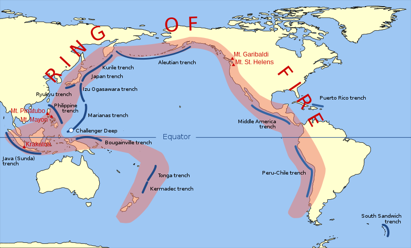
চিত্র:Pacific Ring of Fire.svg

এই SVG ফাইলের জন্য এই PNG প্রাকদর্শনের আকার: ৮০০ × ৪৮৩ পিক্সেল। অন্যান্য আকারসমূহ: ৩২০ × ১৯৩ পিক্সেল | ৬৪০ × ৩৮৭ পিক্সেল | ১,০২৪ × ৬১৯ পিক্সেল | ১,২৮০ × ৭৭৩ পিক্সেল | ২,৫৬০ × ১,৫৪৬ পিক্সেল | ৯৪২ × ৫৬৯ পিক্সেল।
পূর্ণ রেজোলিউশন (এসভিজি ফাইল, সাধারণত ৯৪২ × ৫৬৯ পিক্সেল, ফাইলের আকার: ২৯৪ কিলোবাইট)
ফাইলের ইতিহাস
যেকোনো তারিখ/সময়ে ক্লিক করে দেখুন ফাইলটি তখন কী অবস্থায় ছিল।
| তারিখ/সময় | সংক্ষেপচিত্র | মাত্রা | ব্যবহারকারী | মন্তব্য | |
|---|---|---|---|---|---|
| বর্তমান | ১১:৩০, ২০ মার্চ ২০১৫ |  | ৯৪২ × ৫৬৯ (২৯৪ কিলোবাইট) | Szczureq | Ryuku → Ryukyu |
| ১৩:১৯, ১৫ মার্চ ২০১১ |  | ৯৪২ × ৫৬৯ (২৯৪ কিলোবাইট) | AnonMoos | trimming transparent margins | |
| ১৯:২৫, ৩ মার্চ ২০০৯ |  | ৭৯৬ × ৪৭২ (৩১৪ কিলোবাইট) | Kmusser | Fix volanco symbols | |
| ১৯:০৪, ৩ মার্চ ২০০৯ |  | ৭৯৬ × ৪৭২ (৩১৭ কিলোবাইট) | Kmusser | repositioned volcanoes | |
| ২৩:২৪, ১৩ ফেব্রুয়ারি ২০০৯ |  | ৭৮১ × ৪৭২ (১৪৫ কিলোবাইট) | Inductiveload | added volcanos | |
| ১৭:১৮, ১১ ফেব্রুয়ারি ২০০৯ |  | ৭৮১ × ৪৭২ (১৩৮ কিলোবাইট) | Inductiveload | added labels, aluetian isles and south sandwich islands, as these are associated with the nearby trenches. also put everything into layers. | |
| ২৩:৫৮, ১০ ফেব্রুয়ারি ২০০৯ |  | ৭৮১ × ৪৭২ (১১১ কিলোবাইট) | Gringer | Resized image 3x so that nominal size is reasonable in default Wikipedia image display. | |
| ২৩:৫২, ১০ ফেব্রুয়ারি ২০০৯ |  | ২৬০ × ১৫৭ (১১২ কিলোবাইট) | Gringer | {{Information |Description={{en|1=SVG version of File:Pacific_Ring_of_Fire.png, recreated by me using WDB vector data using code mentioned in File:Worldmap_wdb_combined.svg.}} |Source=vector data from [http://www.evl.uic.edu/pape/data/WDB/] |Aut |
সংযোগসমূহ
নিচের পৃষ্ঠা(গুলো) থেকে এই ছবিতে সংযোগ আছে:
ফাইলের বৈশ্বিক ব্যবহার
নিচের অন্যান্য উইকিগুলো এই ফাইলটি ব্যবহার করে:
- af.wikipedia.org-এ ব্যবহার
- ar.wikipedia.org-এ ব্যবহার
- ast.wikipedia.org-এ ব্যবহার
- ban.wikipedia.org-এ ব্যবহার
- bcl.wikipedia.org-এ ব্যবহার
- bg.wikipedia.org-এ ব্যবহার
- bs.wikipedia.org-এ ব্যবহার
- da.wikipedia.org-এ ব্যবহার
- el.wikipedia.org-এ ব্যবহার
- en.wikipedia.org-এ ব্যবহার
- en.wikibooks.org-এ ব্যবহার
- en.wikivoyage.org-এ ব্যবহার
- en.wiktionary.org-এ ব্যবহার
- es.wikipedia.org-এ ব্যবহার
- fa.wikipedia.org-এ ব্যবহার
- fi.wikipedia.org-এ ব্যবহার
- he.wikipedia.org-এ ব্যবহার
- hi.wikipedia.org-এ ব্যবহার
- hu.wikipedia.org-এ ব্যবহার
- ilo.wikipedia.org-এ ব্যবহার
- incubator.wikimedia.org-এ ব্যবহার
- is.wikipedia.org-এ ব্যবহার
- is.wikibooks.org-এ ব্যবহার
- it.wikibooks.org-এ ব্যবহার
- ja.wikipedia.org-এ ব্যবহার
- ja.wikibooks.org-এ ব্যবহার
- jv.wikipedia.org-এ ব্যবহার
- ka.wikipedia.org-এ ব্যবহার
- kk.wikipedia.org-এ ব্যবহার
- la.wikipedia.org-এ ব্যবহার
এই ফাইলের অন্যান্য বৈশ্বিক ব্যবহার দেখুন।


