
চিত্র:Nigeria 1960-1963.png
এই প্রাকদর্শনের আকার: ৬৭৬ × ৬০০ পিক্সেল। অন্যান্য আকারসমূহ: ২৭১ × ২৪০ পিক্সেল | ৫৪১ × ৪৮০ পিক্সেল | ৮৬৬ × ৭৬৮ পিক্সেল | ১,১৫৪ × ১,০২৪ পিক্সেল | ১,৮৬৯ × ১,৬৫৮ পিক্সেল।
পূর্ণ রেজোলিউশন (১,৮৬৯ × ১,৬৫৮ পিক্সেল, ফাইলের আকার: ৯০ কিলোবাইট, এমআইএমই ধরন: image/png)
| এই ফাইলটি উইকিমিডিয়া কমন্স থেকে নেওয়া। সেখানের বর্ণনা পাতার বিস্তারিত নিম্নে দেখানো হলো। (সম্পাদনা)
|

|
This historical map image could be re-created using vector graphics as an SVG file. This has several advantages; see Commons:Media for cleanup for more information. If an SVG form of this image is available, please upload it and afterwards replace this template with
{{vector version available|new image name}}.
It is recommended to name the SVG file “Nigeria 1960-1963.svg”—then the template Vector version available (or Vva) does not need the new image name parameter. |
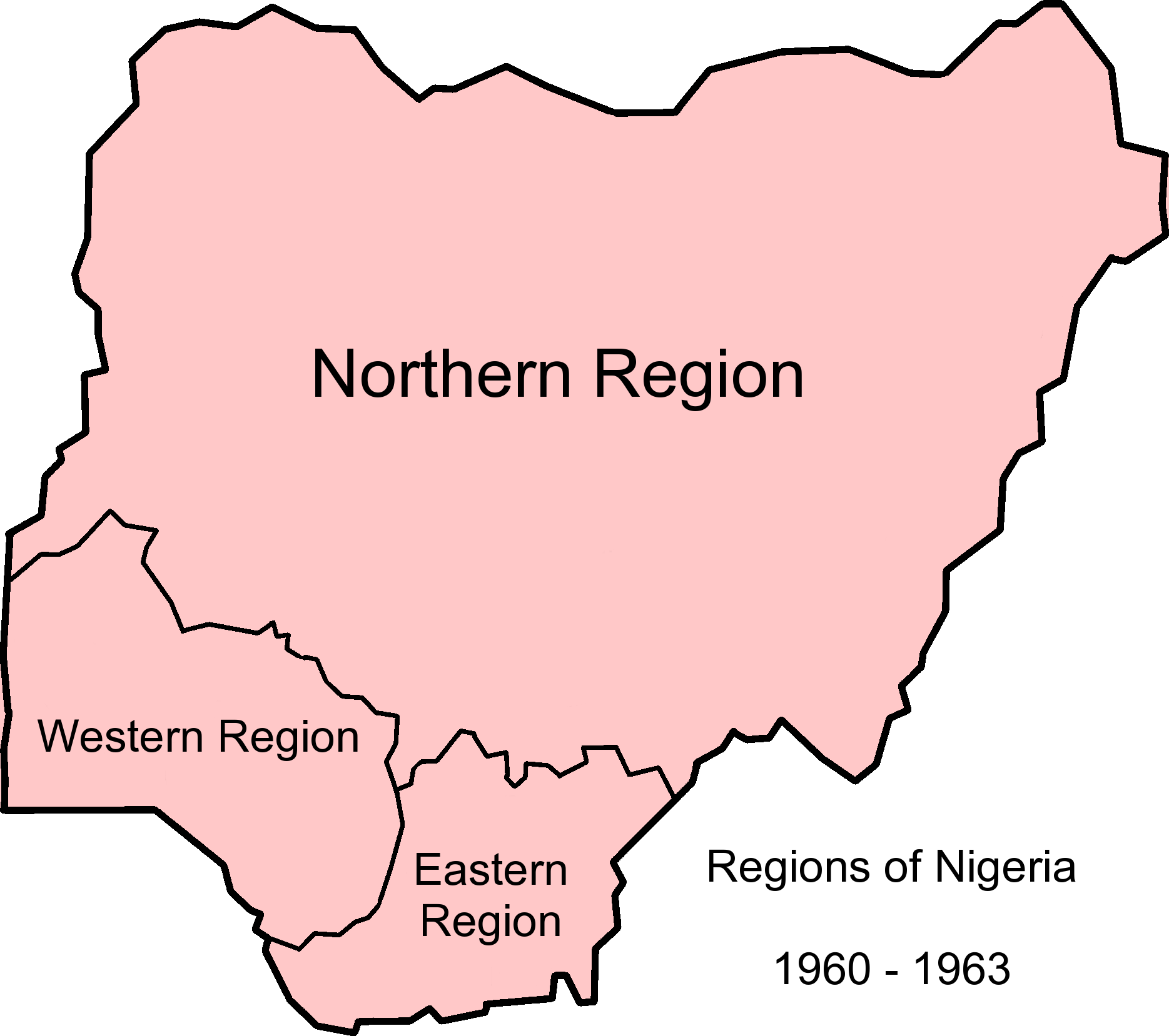
| বিবরণ | Map of Nigerian regions, 1960-1963. Info from http://www.statoids.com/ung.html, http://www.zum.de/whkmla/region/westafrica/nigeriaind.html and http://hdl.loc.gov/loc.gmd/g8840.ct003019 |
| তারিখ | (UTC) |
| উৎস | |
| লেখক |
|
এই ফাইলটি ক্রিয়েটিভ কমন্স অ্যাট্রিবিউশন-শেয়ার অ্যালাইক ৩.০ আনপোর্টেড লাইসেন্সের আওতায় লাইসেন্সকৃত।
- আপনি স্বাধীনভাবে:
- বণ্টন করতে পারেন – এ কাজটি অনুলিপি, বিতরণ এবং প্রেরণ করতে পারেন
- পুনঃমিশ্রণ করতে পারেন – কাজটি অভিযোজন করতে পারেন
- নিম্নের শর্তাবলীর ভিত্তিতে:
- স্বীকৃতিপ্রদান – আপনাকে অবশ্যই যথাযথ স্বীকৃতি প্রদান করতে হবে, লাইসেন্সের একটি লিঙ্ক সরবরাহ করতে হবে এবং কোনো পরিবর্তন হয়েছে কিনা তা নির্দেশ করতে হবে। আপনি যেকোনো যুক্তিসঙ্গত পদ্ধতিতে এটি করতে পারেন। কিন্তু এমন ভাবে নয়, যাতে প্রকাশ পায় যে লাইসেন্সধারী আপনাকে বা আপনার এই ব্যবহারের জন্য অনুমোদন দিয়েছে।
- একইভাবে বণ্টন – আপনি যদি কাজটি পুনঃমিশ্রণ, রুপান্তর, বা এর ওপর ভিত্তি করে নতুন সৃষ্টিকর্ম তৈরি করেন, তবে আপনাকে অবশ্যই আপনার অবদান একই লাইসেন্স বা একই রকমের লাইসেন্সের আওতায় বিতরণ করতে হবে।
মূল আপলোড লগ
This image is a derivative work of the following images:
- File:Nigeria_1963-1967.png licensed with Cc-by-sa-3.0-migrated, GFDL
- 2010-12-09T12:52:32Z StalwartUK 1869x1658 (103207 Bytes) {{Information |Description=Map of Nigerian regions, 1963-1967. Info from http://www.statoids.com/ung.html, http://www.zum.de/whkmla/region/westafrica/nigeriaind.html and http://hdl.loc.gov/loc.gmd/g8840.ct003019 |Source=*[[:F
- File:Nigeria_states-1967-1976.png licensed with Cc-by-sa-3.0-migrated, GFDL
- 2010-04-21T21:32:04Z Bejnar 1869x1658 (140363 Bytes) {{Information |Description=Map of Nigerian states, 1967 - 1976, from data from United States Geological Survey, Africa Data Dissemination Service. |Source=*[[:File:Nigeria_states-1976-1987.png|]] |Date=2010-04-21 21:30 (UTC)
Uploaded with derivativeFX
ফাইলের ইতিহাস
যেকোনো তারিখ/সময়ে ক্লিক করে দেখুন ফাইলটি তখন কী অবস্থায় ছিল।
| তারিখ/সময় | সংক্ষেপচিত্র | মাত্রা | ব্যবহারকারী | মন্তব্য | |
|---|---|---|---|---|---|
| বর্তমান | ১২:৫৭, ৯ ডিসেম্বর ২০১০ | | ১,৮৬৯ × ১,৬৫৮ (৯০ কিলোবাইট) | StalwartUK | {{Information |Description=Map of Nigerian regions, 1960-1963. Info from http://www.statoids.com/ung.html, http://www.zum.de/whkmla/region/westafrica/nigeriaind.html and http://hdl.loc.gov/loc.gmd/g8840.ct003019 |Source=*File:Nigeria_1963-1967.png * |
সংযোগসমূহ
নিচের পৃষ্ঠা(গুলো) থেকে এই ছবিতে সংযোগ আছে:
ফাইলের বৈশ্বিক ব্যবহার
নিচের অন্যান্য উইকিগুলো এই ফাইলটি ব্যবহার করে:
- ca.wikipedia.org-এ ব্যবহার
- de.wikipedia.org-এ ব্যবহার
- en.wikipedia.org-এ ব্যবহার
- eo.wikipedia.org-এ ব্যবহার
- es.wikipedia.org-এ ব্যবহার
- et.wikipedia.org-এ ব্যবহার
- ha.wikipedia.org-এ ব্যবহার
- hy.wikipedia.org-এ ব্যবহার
- incubator.wikimedia.org-এ ব্যবহার
- ja.wikipedia.org-এ ব্যবহার
- vi.wikipedia.org-এ ব্যবহার
- zh.wikipedia.org-এ ব্যবহার