
চিত্র:Mongolei-Topografie,Atlas1903.JPG
পূর্ণ রেজোলিউশন (৮৭৯ × ৭২৫ পিক্সেল, ফাইলের আকার: ১৬৭ কিলোবাইট, এমআইএমই ধরন: image/jpeg)
| এই ফাইলটি উইকিমিডিয়া কমন্স থেকে নেওয়া। সেখানের বর্ণনা পাতার বিস্তারিত নিম্নে দেখানো হলো। (সম্পাদনা)
|
| বিবরণ |
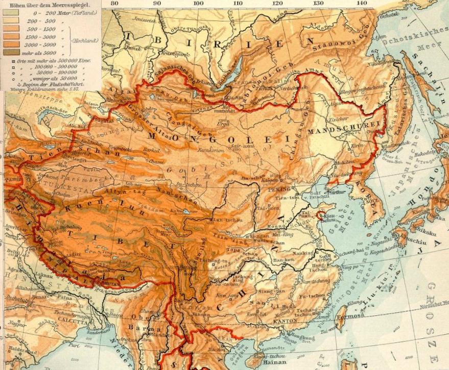
Deutsch: Topografie der Mongolei |
| তারিখ | |
| উৎস | de.wikipedia থেকে কমন্সে স্থানান্তরিত করা হয়েছে। See also Datei:OstasienTopografie.jpg, Ausschnitt aus Verhagen-Atlas 1903) |
| লেখক | Geof (Bearb. +Kartenlegende) |
লাইসেন্স প্রদান
|
এই কর্মটি এর উৎস দেশে পাবলিক ডোমেইনে রয়েছে এবং অন্যান্য দেশ ও অঞ্চলে যেখানে কপিরাটের সময়সীমা হচ্ছে লেখকের জীবন যোগ ৭০ বছর বা তাঁর কম।
| |
| এই ফাইলটি কপিরাইট আইনের আওতায় জানা সকল বাধানিষেধ মুক্ত বলে চিহ্নিত হয়েছে, যার মধ্যে সম্পর্কিত সকল স্বত্ব ও নেইবারিং সত্ত্ব সংযুক্ত। | |
মূল আপলোড লগ
- 2009-03-25 17:12 Geof 871×621× (194656 bytes) {{Information |Beschreibung = Topografie der Mongolei |Quelle = [Datei:OstasienTopografie.jpg], Ausschnitt aus Verhagen-Atlas 1903 |Urheber = Geof (Bearb. +Kartenlegende) |Datum = 25.3.2009 |Andere Versionen = |Anmerkungen = }}
| Annotations | This image is annotated: View the annotations at Commons |
ফাইলের ইতিহাস
যেকোনো তারিখ/সময়ে ক্লিক করে দেখুন ফাইলটি তখন কী অবস্থায় ছিল।
| তারিখ/সময় | সংক্ষেপচিত্র | মাত্রা | ব্যবহারকারী | মন্তব্য | |
|---|---|---|---|---|---|
| বর্তমান | ১৫:০৬, ১১ অক্টোবর ২০১৯ | | ৮৭৯ × ৭২৫ (১৬৭ কিলোবাইট) | Бмхүн | {{DEFAULTSORT:}} |
| ১৫:০৪, ১১ অক্টোবর ২০১৯ |  | ৮৭৯ × ৭২৫ (৮৯২ কিলোবাইট) | Бмхүн | {{NAMESPACE}}{{DEFAULTSORT:<languages/><code><nowiki></nowiki></code>}} | |
| ০৯:২৩, ১৫ নভেম্বর ২০০৯ |  | ৮৭১ × ৬২১ (১৯০ কিলোবাইট) | Gikü | {{Information |Description={{de|Topografie der Mongolei}} |Source=Transferred from [http://de.wikipedia.org de.wikipedia]. See also de::Datei:OstasienTopografie.jpg, Ausschnitt aus Verhagen-Atlas 1903'') |Date={{Date|2009|03|25}} |Author=Geof (Bearb |
সংযোগসমূহ
নিচের পৃষ্ঠা(গুলো) থেকে এই ছবিতে সংযোগ আছে:
ফাইলের বৈশ্বিক ব্যবহার
নিচের অন্যান্য উইকিগুলো এই ফাইলটি ব্যবহার করে:
- ba.wikipedia.org-এ ব্যবহার
- ca.wikipedia.org-এ ব্যবহার
- cs.wikipedia.org-এ ব্যবহার
- de.wikipedia.org-এ ব্যবহার
- el.wikipedia.org-এ ব্যবহার
- en.wikipedia.org-এ ব্যবহার
- eo.wikipedia.org-এ ব্যবহার
- es.wikipedia.org-এ ব্যবহার
- eu.wikipedia.org-এ ব্যবহার
- fa.wikipedia.org-এ ব্যবহার
- fi.wikipedia.org-এ ব্যবহার
- gl.wikipedia.org-এ ব্যবহার
- hr.wikipedia.org-এ ব্যবহার
- it.wikipedia.org-এ ব্যবহার
- ml.wikipedia.org-এ ব্যবহার
- mn.wikipedia.org-এ ব্যবহার
- no.wikipedia.org-এ ব্যবহার
- ro.wikipedia.org-এ ব্যবহার
- sl.wikipedia.org-এ ব্যবহার
- sr.wikipedia.org-এ ব্যবহার
- sw.wikipedia.org-এ ব্যবহার
- tr.wikipedia.org-এ ব্যবহার
- www.wikidata.org-এ ব্যবহার
- zh.wikipedia.org-এ ব্যবহার