
চিত্র:Michigan Lower Peninsula Regions.png
এর চেয়ে বেশি রেজোলিউশন লভ্য নয়।
Michigan_Lower_Peninsula_Regions.png (২৯২ × ২৭৮ পিক্সেল, ফাইলের আকার: ৩০ কিলোবাইট, এমআইএমই ধরন: image/png)
| এই ফাইলটি উইকিমিডিয়া কমন্স থেকে নেওয়া। সেখানের বর্ণনা পাতার বিস্তারিত নিম্নে দেখানো হলো। (সম্পাদনা)
|
সারাংশ
| বিবরণ |
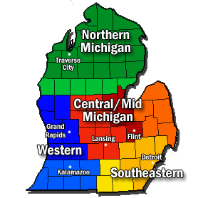
English: The four major geographical and economical regions of the Lower Peninsula of State of Michigan. Includes: Northern Michigan (Greens), Mid-Michigan (Reds and oranges), Western Michigan (Blues), and Southeast Michigan (Yellows). Generally accepted principal regions are shaded dark, while overlapping areas and sub-regions are shaded lightly. PLEASE NOTE All regions and boundaries are relative. This a compilation of many different region maps, including [1] and [2] |
| তারিখ | |
| উৎস | নিজের কাজ |
| লেখক | Mac1island |
![[1]](https://en.wikipedia.org/wiki/File:Lower_Michigan_Region_Map.png)
![[2]](https://en.wikipedia.org/wiki/File:Michigan_Regions.svg)
লাইসেন্স প্রদান
আমি, এই কাজের স্বত্বাধিকারী, এতদ্দ্বারা আমি এই কাজকে নিম্ন বর্ণিত লাইসেন্সের আওতায় প্রকাশ করলাম:
এই ফাইলটি ক্রিয়েটিভ কমন্স অ্যাট্রিবিউশন-শেয়ার অ্যালাইক ৩.০ আনপোর্টেড লাইসেন্সের আওতায় লাইসেন্সকৃত।
- আপনি স্বাধীনভাবে:
- বণ্টন করতে পারেন – এ কাজটি অনুলিপি, বিতরণ এবং প্রেরণ করতে পারেন
- পুনঃমিশ্রণ করতে পারেন – কাজটি অভিযোজন করতে পারেন
- নিম্নের শর্তাবলীর ভিত্তিতে:
- স্বীকৃতিপ্রদান – আপনাকে অবশ্যই যথাযথ স্বীকৃতি প্রদান করতে হবে, লাইসেন্সের একটি লিঙ্ক সরবরাহ করতে হবে এবং কোনো পরিবর্তন হয়েছে কিনা তা নির্দেশ করতে হবে। আপনি যেকোনো যুক্তিসঙ্গত পদ্ধতিতে এটি করতে পারেন। কিন্তু এমন ভাবে নয়, যাতে প্রকাশ পায় যে লাইসেন্সধারী আপনাকে বা আপনার এই ব্যবহারের জন্য অনুমোদন দিয়েছে।
- একইভাবে বণ্টন – আপনি যদি কাজটি পুনঃমিশ্রণ, রুপান্তর, বা এর ওপর ভিত্তি করে নতুন সৃষ্টিকর্ম তৈরি করেন, তবে আপনাকে অবশ্যই আপনার অবদান একই লাইসেন্স বা একই রকমের লাইসেন্সের আওতায় বিতরণ করতে হবে।
ফাইলের ইতিহাস
যেকোনো তারিখ/সময়ে ক্লিক করে দেখুন ফাইলটি তখন কী অবস্থায় ছিল।
| তারিখ/সময় | সংক্ষেপচিত্র | মাত্রা | ব্যবহারকারী | মন্তব্য | |
|---|---|---|---|---|---|
| বর্তমান | ০০:৫৬, ১৪ ফেব্রুয়ারি ২০১২ | | ২৯২ × ২৭৮ (৩০ কিলোবাইট) | Mac1island | Added "Michigan" to "Central/Mid" |
| ০০:২৭, ১৪ ফেব্রুয়ারি ২০১২ |  | ২৯২ × ২৭৮ (২৯ কিলোবাইট) | Mac1island | Central/Mid Michigan are synonymous terms. | |
| ২২:৩৩, ২১ নভেম্বর ২০১১ |  | ২৯২ × ২৭৮ (২৮ কিলোবাইট) | Mac1island | Please note changes in shading. After discussion and further research, the Central Michigan area (orange) is expanded. Separate shading was done for the southern Michigan area around Kalamazoo (light blue) and also around Jackson (light yellow) | |
| ২০:৪৫, ২০ নভেম্বর ২০১১ |  | ২৯২ × ২৭৮ (২৯ কিলোবাইট) | Mac1island | Added Kalamazoo to the area of Southern Michigan. Outlined city text. | |
| ১৮:২২, ২০ নভেম্বর ২০১১ |  | ২৯২ × ২৭৮ (২৯ কিলোবাইট) | Mac1island | A simplified and modified version based on five principle regions and their subsuquent overlapping sub-regions. All boundaries are relative. Principal regions are dark shaded, while overlapping regions are lightly shaded. | |
| ২৩:১৬, ১৯ নভেম্বর ২০১১ |  | ৫০৭ × ৪৭৪ (৭৬ কিলোবাইট) | Mac1island |
সংযোগসমূহ
নিচের পৃষ্ঠা(গুলো) থেকে এই ছবিতে সংযোগ আছে:
ফাইলের বৈশ্বিক ব্যবহার
নিচের অন্যান্য উইকিগুলো এই ফাইলটি ব্যবহার করে:
- de.wikipedia.org-এ ব্যবহার
- en.wikipedia.org-এ ব্যবহার
- nl.wikipedia.org-এ ব্যবহার
- simple.wikipedia.org-এ ব্যবহার
- zh.wikipedia.org-এ ব্যবহার