
চিত্র:Map of the Arctic region showing the Northeast Passage, the Northern Sea Route and Northwest Passage, and bathymetry.png

এই প্রাকদর্শনের আকার: ৬৩২ × ৬০০ পিক্সেল। অন্যান্য আকারসমূহ: ২৫৩ × ২৪০ পিক্সেল | ৫০৬ × ৪৮০ পিক্সেল | ১,০০৩ × ৯৫২ পিক্সেল।
পূর্ণ রেজোলিউশন (১,০০৩ × ৯৫২ পিক্সেল, ফাইলের আকার: ৭৫৮ কিলোবাইট, এমআইএমই ধরন: image/png)
| এই ফাইলটি উইকিমিডিয়া কমন্স থেকে নেওয়া। সেখানের বর্ণনা পাতার বিস্তারিত নিম্নে দেখানো হলো। (সম্পাদনা)
|
সারাংশ
| বিবরণ |
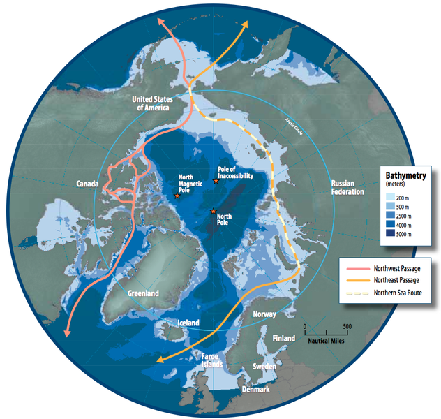
English: Map of the Arctic region showing shipping routes Northeast Passage, Northern Sea Route, and Northwest Passage, and bathymetry |
| তারিখ | |
| উৎস | Arctic Council - Arctic marine shipping assessment - http://www.arctic.noaa.gov/detect/documents/AMSA_2009_Report_2nd_print.pdf |
| লেখক | Susie Harder |
লাইসেন্স প্রদান
This file is in the public domain because the work was created/published by the Arctic Council, an international organization
|
ফাইলের ইতিহাস
যেকোনো তারিখ/সময়ে ক্লিক করে দেখুন ফাইলটি তখন কী অবস্থায় ছিল।
| তারিখ/সময় | সংক্ষেপচিত্র | মাত্রা | ব্যবহারকারী | মন্তব্য | |
|---|---|---|---|---|---|
| বর্তমান | ১৬:৪৬, ১৯ অক্টোবর ২০১৪ | | ১,০০৩ × ৯৫২ (৭৫৮ কিলোবাইট) | Al83tito | User created page with UploadWizard |
সংযোগসমূহ
নিচের পৃষ্ঠা(গুলো) থেকে এই ছবিতে সংযোগ আছে:
ফাইলের বৈশ্বিক ব্যবহার
নিচের অন্যান্য উইকিগুলো এই ফাইলটি ব্যবহার করে:
- de.wikipedia.org-এ ব্যবহার
- en.wikipedia.org-এ ব্যবহার
- es.wikipedia.org-এ ব্যবহার
- fa.wikipedia.org-এ ব্যবহার
- fr.wikipedia.org-এ ব্যবহার
- he.wikipedia.org-এ ব্যবহার
- hr.wikipedia.org-এ ব্যবহার
- hu.wikipedia.org-এ ব্যবহার
- id.wikipedia.org-এ ব্যবহার
- it.wikipedia.org-এ ব্যবহার
- ja.wikipedia.org-এ ব্যবহার
- ko.wikipedia.org-এ ব্যবহার
- nl.wikipedia.org-এ ব্যবহার
- pl.wikipedia.org-এ ব্যবহার
- pt.wikipedia.org-এ ব্যবহার
- ru.wikipedia.org-এ ব্যবহার
- sd.wikipedia.org-এ ব্যবহার
- te.wikipedia.org-এ ব্যবহার
- th.wikipedia.org-এ ব্যবহার
- tr.wikipedia.org-এ ব্যবহার