
চিত্র:Map of The Hotakids.png
এর চেয়ে বেশি রেজোলিউশন লভ্য নয়।
Map_of_The_Hotakids.png (৬২০ × ৪২৯ পিক্সেল, ফাইলের আকার: ২৭ কিলোবাইট, এমআইএমই ধরন: image/png)
| এই ফাইলটি উইকিমিডিয়া কমন্স থেকে নেওয়া। সেখানের বর্ণনা পাতার বিস্তারিত নিম্নে দেখানো হলো। (সম্পাদনা)
|
সারাংশ
| বিবরণ |
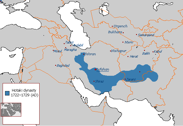
English: Map of The Hotakids from 1722 to 1729 |
| তারিখ | ২৯ আগস্ট ২০০৭ (মূল আপলোডের তারিখ) |
| উৎস |
নিজের কাজ, Sources consulted in the making of this map include: The Fall of the Safavi Dynasty and the Afghan Occupation of Persia by Laurence Lockhart The Afghan Occupation of Safavid Persia 1721-1729 by Willem Floor Articles from Encyclopedia Iranica History of the Wars 1721-1738 by Abraham of Erevan and translated by George A. Bournoutian The Chronicles of a Traveller: Or, A History of the Afghan Wars with Persia by Tadeusz Judas Krusiński |
| লেখক | ইংরেজি উইকিপিডিয়া-এর Arab Hafez |
লাইসেন্স প্রদান
| এই কাজের প্রণেতা ইংরেজি উইকিপিডিয়া-এর Arab Hafez কাজটি পাবলিক ডোমেইনে প্রকাশ করেছেন। এটি বিশ্বব্যাপী প্রযোজ্য হবে। কিছু দেশে এটি আইনত সিদ্ধ নাও হতে পারে, যদি তাই হয়: Arab Hafez যে-কাউকে যেকোনো উদ্দেশ্যে, বিনাশর্তে এই কাজটি ব্যবহারের অনুমতি প্রদান করেন, যদি না সেই শর্তগুলো আইনত প্রয়োজনীয় হয়। |
মূল আপলোড লগ
en.wikipedia থেকে কমন্সে স্থানান্তরিত করা হয়েছে।
মূল বিবরণ পাতাটি এখানে ছিল। নিম্নলিখিত সকল ব্যবহারকারীর নাম en.wikipedia-এ উল্লেখ করা ছিল।
- 2007-08-29 21:49 Arab Hafez 620×429× (24487 bytes)
ফাইলের ইতিহাস
যেকোনো তারিখ/সময়ে ক্লিক করে দেখুন ফাইলটি তখন কী অবস্থায় ছিল।
| তারিখ/সময় | সংক্ষেপচিত্র | মাত্রা | ব্যবহারকারী | মন্তব্য | |
|---|---|---|---|---|---|
| বর্তমান | ১৩:৪২, ১৭ আগস্ট ২০২১ | | ৬২০ × ৪২৯ (২৭ কিলোবাইট) | Kailanmapper | Reverted to version as of 16:37, 31 July 2021 (UTC) if you would read the sources you would know its accurate |
| ২১:২০, ১৫ আগস্ট ২০২১ |  | ৬২০ × ৪২৯ (১৮ কিলোবাইট) | Casperti | Reverted to version as of 12:38, 31 July 2021 (UTC) Do not engage in a conflict on Wiki commons open a discussion where you get consensus for it | |
| ১৬:৩৭, ৩১ জুলাই ২০২১ |  | ৬২০ × ৪২৯ (২৭ কিলোবাইট) | Noorullah21 | Reverted to version as of 12:51, 28 July 2021 (UTC) Final edit before this traerses to an edit war, first of all, the ottoman hotak war ended 1-2 years prior to this map, this map is a 1728-1729 hotak map. 2. The old map is incredibly inaccurate, and exaggerated claims throughout, it is unsourced and a wrong map. Hence why it is being replaced with the one Kalilan made, a much more accurate map. | |
| ১২:৩৮, ৩১ জুলাই ২০২১ |  | ৬২০ × ৪২৯ (১৮ কিলোবাইট) | Casperti | Reverted to version as of 10:58, 28 July 2021 (UTC) Against all reliable sources and consensus. Besides the Ottoman-Hotak war Is here ignored | |
| ১২:৫১, ২৮ জুলাই ২০২১ |  | ৬২০ × ৪২৯ (২৭ কিলোবাইট) | Kailanmapper | Reverted to version as of 03:16, 28 July 2021 (UTC) the ip addresses involved haven't even tried to address my claims after several days. Plus Wikipedia literally says that unsourced information should be challenged and removed. I initially uploaded my own work separately but it got removed countless times from those very ip adresses who are refusing to say anything | |
| ১০:৫৮, ২৮ জুলাই ২০২১ |  | ৬২০ × ৪২৯ (১৮ কিলোবাইট) | Xerxes1985 | Reverted to version as of 02:20, 28 July 2021 (UTC)inaccurate or accurate doesn’t matter, Again, where’s your consensus for this version? Upload your own work separately if you want to | |
| ০৩:১৬, ২৮ জুলাই ২০২১ |  | ৬২০ × ৪২৯ (২৭ কিলোবাইট) | Kailanmapper | Reverted to version as of 20:53, 27 July 2021 (UTC) again, that is inaccurate and unsourced | |
| ০২:২০, ২৮ জুলাই ২০২১ |  | ৬২০ × ৪২৯ (১৮ কিলোবাইট) | Xerxes1985 | Reverted to version as of 11:10, 27 July 2021 (UTC) No consensus for this map | |
| ২০:৫৩, ২৭ জুলাই ২০২১ |  | ৬২০ × ৪২৯ (২৭ কিলোবাইট) | Noorullah21 | The old map is inaccurate, read the talk page please. | |
| ১১:১০, ২৭ জুলাই ২০২১ |  | ৬২০ × ৪২৯ (১৮ কিলোবাইট) | Mukhis125 | Reverted to version as of 08:28, 19 August 2011 (UTC) |
সংযোগসমূহ
নিচের পৃষ্ঠা(গুলো) থেকে এই ছবিতে সংযোগ আছে:
ফাইলের বৈশ্বিক ব্যবহার
নিচের অন্যান্য উইকিগুলো এই ফাইলটি ব্যবহার করে:
- ar.wikipedia.org-এ ব্যবহার
- ast.wikipedia.org-এ ব্যবহার
- en.wikipedia.org-এ ব্যবহার
- eo.wikipedia.org-এ ব্যবহার
- et.wikipedia.org-এ ব্যবহার
- fa.wikipedia.org-এ ব্যবহার
- fi.wikipedia.org-এ ব্যবহার
- he.wikipedia.org-এ ব্যবহার
- hr.wikipedia.org-এ ব্যবহার
- id.wikipedia.org-এ ব্যবহার
- it.wikipedia.org-এ ব্যবহার
- nl.wikipedia.org-এ ব্যবহার
- no.wikipedia.org-এ ব্যবহার
- pnb.wikipedia.org-এ ব্যবহার
- ps.wikipedia.org-এ ব্যবহার
- pt.wikipedia.org-এ ব্যবহার
- ru.wikipedia.org-এ ব্যবহার
- sh.wikipedia.org-এ ব্যবহার
- sv.wikipedia.org-এ ব্যবহার
- tg.wikipedia.org-এ ব্যবহার
- tr.wikipedia.org-এ ব্যবহার
- uk.wikipedia.org-এ ব্যবহার
- www.wikidata.org-এ ব্যবহার
- zh.wikipedia.org-এ ব্যবহার