
চিত্র:IslamicConquestsIroon.png
এই প্রাকদর্শনের আকার: ৬৭৫ × ৫৯৯ পিক্সেল। অন্যান্য আকারসমূহ: ২৭০ × ২৪০ পিক্সেল | ৫৪১ × ৪৮০ পিক্সেল | ১,০০৬ × ৮৯৩ পিক্সেল।
পূর্ণ রেজোলিউশন (১,০০৬ × ৮৯৩ পিক্সেল, ফাইলের আকার: ১০৫ কিলোবাইট, এমআইএমই ধরন: image/png)
| এই ফাইলটি উইকিমিডিয়া কমন্স থেকে নেওয়া। সেখানের বর্ণনা পাতার বিস্তারিত নিম্নে দেখানো হলো। (সম্পাদনা)
|

|
This historical map image could be re-created using vector graphics as an SVG file. This has several advantages; see Commons:Media for cleanup for more information. If an SVG form of this image is available, please upload it and afterwards replace this template with
{{vector version available|new image name}}.
It is recommended to name the SVG file “IslamicConquestsIroon.svg”—then the template Vector version available (or Vva) does not need the new image name parameter. |
| বিবরণ |
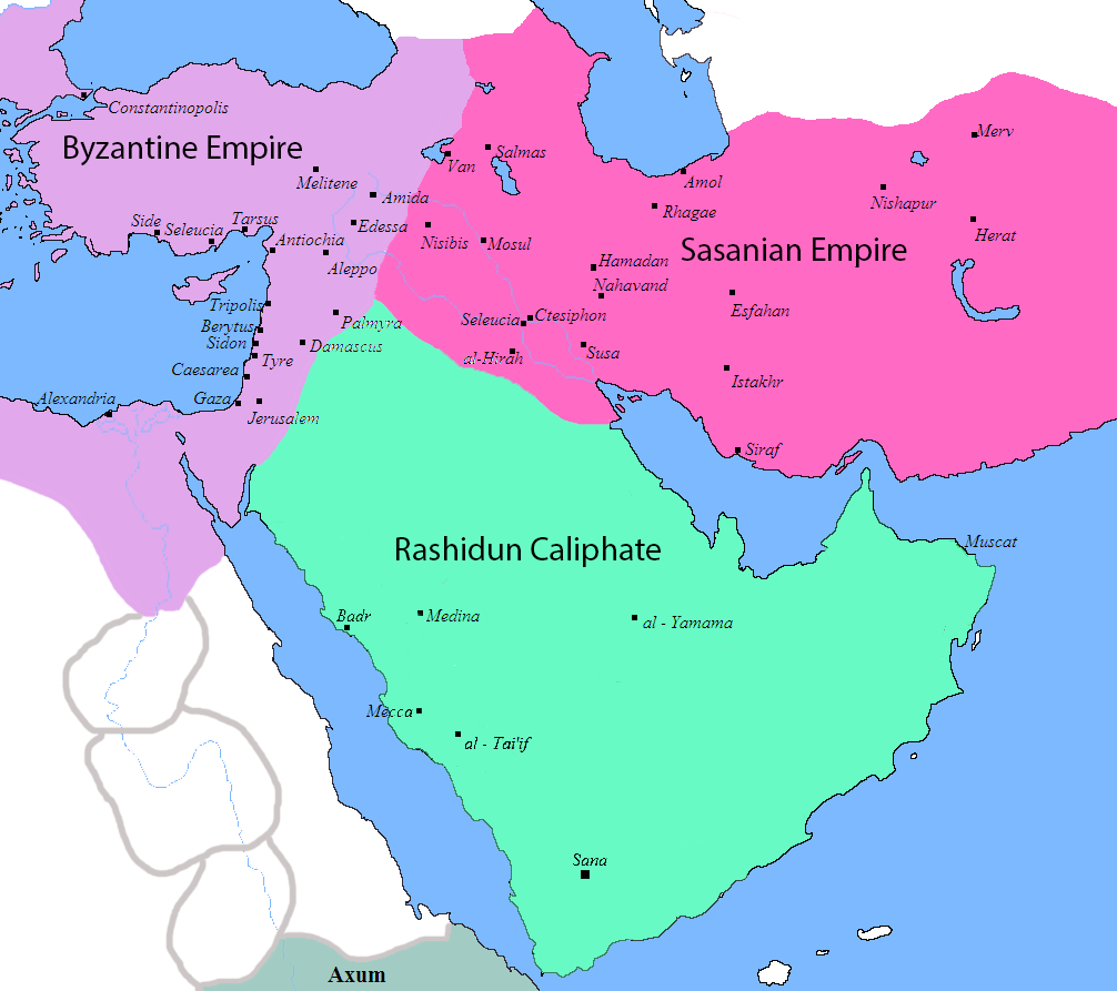
English: Map of the Sassanid, Byzantine and Muslim borders. |
| উৎস | File:Pre_Islamic_Arabia.PNG |
| লেখক | Javierfv1212 and edited by HistoryofIran. |
| অন্যান্য সংস্করণ |
[]
|


This file is in the public domain because File:Pre_Islamic_Arabia.PNG
|
ফাইলের ইতিহাস
যেকোনো তারিখ/সময়ে ক্লিক করে দেখুন ফাইলটি তখন কী অবস্থায় ছিল।
| তারিখ/সময় | সংক্ষেপচিত্র | মাত্রা | ব্যবহারকারী | মন্তব্য | |
|---|---|---|---|---|---|
| বর্তমান | ১০:১৩, ১৮ সেপ্টেম্বর ২০১৯ | | ১,০০৬ × ৮৯৩ (১০৫ কিলোবাইট) | HistoryofIran | rv, thats not how it works |
| ০৪:৫১, ১৮ সেপ্টেম্বর ২০১৯ |  | ১,০০৬ × ৮৯৩ (১০৩ কিলোবাইট) | Сахалин21 | Under Hormizd IV, Persia won the Perso-Turkic War and conquered Samarqand and the Transoxiania. | |
| ০৪:৫০, ১৮ সেপ্টেম্বর ২০১৯ |  | ১,০০৬ × ৮৯৩ (১০৫ কিলোবাইট) | Сахалин21 | Reverted to version as of 01:15, 3 August 2019 (UTC) | |
| ০৪:৪৫, ১৮ সেপ্টেম্বর ২০১৯ |  | ১,০০৬ × ৮৯৩ (১০৩ কিলোবাইট) | Сахалин21 | Reverted to version as of 19:13, 14 November 2017 (UTC) | |
| ০১:১৫, ৩ আগস্ট ২০১৯ |  | ১,০০৬ × ৮৯৩ (১০৫ কিলোবাইট) | HistoryofIran | rv, no, they weren't at all | |
| ১৮:৩৮, ১ আগস্ট ২০১৯ |  | ১,০০৬ × ৮৯৩ (১০৫ কিলোবাইট) | Mehrdad 12 | The eastern borders were conquered during the reign of Queen Purandokht. | |
| ১৮:৩৪, ১ আগস্ট ২০১৯ |  | ১,০০৬ × ৮৯৩ (১০৬ কিলোবাইট) | Mehrdad 12 | I corrected the eastern borders. The Great Khorasan and Khwarizmi Desert were considered imperial. | |
| ০২:৫১, ১২ ফেব্রুয়ারি ২০১৯ |  | ১,০০৬ × ৮৯৩ (১০৫ কিলোবাইট) | HistoryofIran | Made the map somewhat more accurate, probably more to come. | |
| ১৯:১৩, ১৪ নভেম্বর ২০১৭ |  | ১,০০৬ × ৮৯৩ (১০৩ কিলোবাইট) | HistoryofIran | rv, the Sasanian Empire didnt control that much | |
| ১১:০২, ১২ নভেম্বর ২০১৭ |  | ১,০০৬ × ৮৯৩ (১২৮ কিলোবাইট) | Mehrdad 12 | {{NAMESPACE}}{{PAGENAME}}[[]][[:File:]]]] |
সংযোগসমূহ
নিচের পৃষ্ঠা(গুলো) থেকে এই ছবিতে সংযোগ আছে:
ফাইলের বৈশ্বিক ব্যবহার
নিচের অন্যান্য উইকিগুলো এই ফাইলটি ব্যবহার করে:
- bg.wikipedia.org-এ ব্যবহার
- bn.wikiquote.org-এ ব্যবহার
- bs.wikipedia.org-এ ব্যবহার
- cs.wikipedia.org-এ ব্যবহার
- da.wikipedia.org-এ ব্যবহার
- de.wikipedia.org-এ ব্যবহার
- diq.wikipedia.org-এ ব্যবহার
- en.wikipedia.org-এ ব্যবহার
- fa.wikipedia.org-এ ব্যবহার
- fa.wikibooks.org-এ ব্যবহার
- fi.wikipedia.org-এ ব্যবহার
- fr.wikipedia.org-এ ব্যবহার
- he.wikipedia.org-এ ব্যবহার
- hr.wikipedia.org-এ ব্যবহার
- hy.wikipedia.org-এ ব্যবহার
- hyw.wikipedia.org-এ ব্যবহার
- ka.wikipedia.org-এ ব্যবহার
- ko.wikipedia.org-এ ব্যবহার
- ru.wikipedia.org-এ ব্যবহার
- sr.wikipedia.org-এ ব্যবহার
- sv.wikipedia.org-এ ব্যবহার
- ta.wikipedia.org-এ ব্যবহার
- th.wikipedia.org-এ ব্যবহার
- tr.wikipedia.org-এ ব্যবহার
- uk.wikipedia.org-এ ব্যবহার
- zh.wikipedia.org-এ ব্যবহার