
চিত্র:IndianRailways1871b.jpg

এই প্রাকদর্শনের আকার: ৪৫৮ × ৫৯৯ পিক্সেল। অন্যান্য আকারসমূহ: ১৮৩ × ২৪০ পিক্সেল | ৩৬৭ × ৪৮০ পিক্সেল | ১,০১৮ × ১,৩৩১ পিক্সেল।
পূর্ণ রেজোলিউশন (১,০১৮ × ১,৩৩১ পিক্সেল, ফাইলের আকার: ৯৭৬ কিলোবাইট, এমআইএমই ধরন: image/jpeg)
| এই ফাইলটি উইকিমিডিয়া কমন্স থেকে নেওয়া। সেখানের বর্ণনা পাতার বিস্তারিত নিম্নে দেখানো হলো। (সম্পাদনা)
|
সারাংশ
| বর্ণনা |
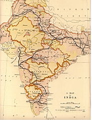
English: Map of Indian Railways in 1871 prepared by the British Government India Office for the House of Commons Committee. |
|||||||||
| তারিখ | ||||||||||
| উৎস | Scanned reduced and uploaded from personal copy by Fowler&fowler«Talk» 00:53, 15 November 2009 (UTC). Transferred from en.wikipedia; transferred to Commons by User:Innotata using CommonsHelper. | |||||||||
| স্রষ্টা |
Saunders Geographers |
|||||||||
| Geotemporal data | ||||||||||
| ভৌগলিক সীমা |
|
|||||||||
| Warper-এ মানচিত্রের আস্তরণ | ||||||||||
লাইসেন্স প্রদান
This work created by the United Kingdom Government is in the public domain.
This is because it is one of the following:
HMSO has declared that the expiry of Crown Copyrights applies worldwide (ref: HMSO Email Reply)
|
 |
মূল আপলোড লগ
মূল বিবরণ পাতাটি এখানে ছিল। নিম্নলিখিত সকল ব্যবহারকারীর নাম en.wikipedia-এ উল্লেখ করা ছিল।
- 2009-11-15 00:53 Fowler&fowler 1018×1331× (999532 bytes) {{Information |Description = Map of Indian Railways in 1871 prepared by the British Government [[India Office]] for the House of Commons Committee. |Source = UK Government India Office Map (personal copy) |Date = 1871 |Author
ফাইলের ইতিহাস
যেকোনো তারিখ/সময়ে ক্লিক করে দেখুন ফাইলটি তখন কী অবস্থায় ছিল।
| তারিখ/সময় | সংক্ষেপচিত্র | মাত্রা | ব্যবহারকারী | মন্তব্য | |
|---|---|---|---|---|---|
| বর্তমান | ২৩:৫৮, ১৬ ফেব্রুয়ারি ২০১১ | | ১,০১৮ × ১,৩৩১ (৯৭৬ কিলোবাইট) | File Upload Bot (Magnus Manske) | {{BotMoveToCommons|en.wikipedia|year={{subst:CURRENTYEAR}}|month={{subst:CURRENTMONTHNAME}}|day={{subst:CURRENTDAY}}}} {{Information |Description={{en|Map of Indian Railways in 1871 prepared by the British Government en:India Office for the House o |
সংযোগসমূহ
নিচের পৃষ্ঠা(গুলো) থেকে এই ছবিতে সংযোগ আছে:
ফাইলের বৈশ্বিক ব্যবহার
নিচের অন্যান্য উইকিগুলো এই ফাইলটি ব্যবহার করে:
- ast.wikipedia.org-এ ব্যবহার
- as.wikipedia.org-এ ব্যবহার
- cs.wikipedia.org-এ ব্যবহার
- en.wikipedia.org-এ ব্যবহার
- Rail transport in India
- Company rule in India
- Indian Railways
- History of science and technology on the Indian subcontinent
- Economic history of India
- Famine in India
- British Raj
- Economy of India under the British Raj
- User:Falcaorib
- User:AustinJAragon/sandbox
- User:Frank.p873/sandbox
- User:Efrain805/British Raj
- User:AustinJAragon/British Raj railway section
- es.wikipedia.org-এ ব্যবহার
- fr.wikipedia.org-এ ব্যবহার
- gu.wikipedia.org-এ ব্যবহার
- he.wikipedia.org-এ ব্যবহার
- hy.wikipedia.org-এ ব্যবহার
- it.wikipedia.org-এ ব্যবহার
- ja.wikipedia.org-এ ব্যবহার
- ml.wikipedia.org-এ ব্যবহার
- mr.wikipedia.org-এ ব্যবহার
- nl.wikipedia.org-এ ব্যবহার
- no.wikipedia.org-এ ব্যবহার
- pt.wikipedia.org-এ ব্যবহার
- sa.wikipedia.org-এ ব্যবহার
- ta.wikipedia.org-এ ব্যবহার
- te.wikipedia.org-এ ব্যবহার
- uk.wikipedia.org-এ ব্যবহার
- vi.wikipedia.org-এ ব্যবহার