
চিত্র:Europe 1812 map en.png

এই প্রাকদর্শনের আকার: ৮০০ × ৫২৬ পিক্সেল। অন্যান্য আকারসমূহ: ৩২০ × ২১১ পিক্সেল | ৬৪০ × ৪২১ পিক্সেল | ১,০২৪ × ৬৭৪ পিক্সেল | ১,২৮০ × ৮৪২ পিক্সেল | ২,২৮৪ × ১,৫০৩ পিক্সেল।
পূর্ণ রেজোলিউশন (২,২৮৪ × ১,৫০৩ পিক্সেল, ফাইলের আকার: ১.১৪ মেগাবাইট, এমআইএমই ধরন: image/png)
| এই ফাইলটি উইকিমিডিয়া কমন্স থেকে নেওয়া। সেখানের বর্ণনা পাতার বিস্তারিত নিম্নে দেখানো হলো। (সম্পাদনা)
|
সারাংশ

|
This historical map image could be re-created using vector graphics as an SVG file. This has several advantages; see Commons:Media for cleanup for more information. If an SVG form of this image is available, please upload it and afterwards replace this template with
{{vector version available|new image name}}.
It is recommended to name the SVG file “Europe 1812 map en.svg”—then the template Vector version available (or Vva) does not need the new image name parameter. |
| বিবরণ |
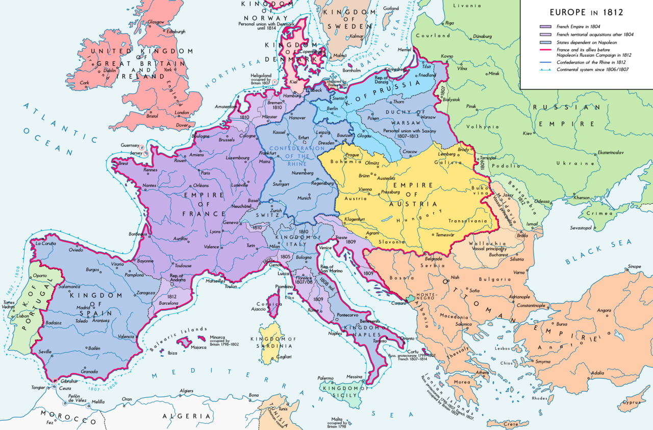
Deutsch: Europa 1812. Politische Ausgangslage vor Napeoleons Russlandfelzug. English: Europe in 1812. Political situation before Napoleon's Russian Campaign. |
| তারিখ | |
| উৎস |
নিজের কাজ. Source of Information: – Map "L'apogée de l'Empire Français (avant la campagne de Russie)" (Author unknown)(Link) – Dr. Walter Leiserung (ed.): Historischer Weltatlas, Marix Verlag, Wiesbaden 2004, ISBN 978-3-937715-59-9 – Zentralinstitut für Geschichte der Akademie der Wissenschaften der DDR (ed.): Atlas zur Geschichte, Band 1, VEB Hermann Haack, Gotha 1989, ISBN 3-7301-0040-8 – Prof. Dr. Vadim Oswalt, Prof. Dr. Hans Ulrich Rudolf (ed.): Klett-Perthes Atlas zur Weltgeschichte, Ernst Klett Verlag, Stuttgart 2011, ISBN 978-3-12-828194-0 – Ferenc Majoros u. Bernd Rill: Das Osmanische Reich 1300-1922. Die Geschichte einer Großmacht, Lzenzausgabe für Weltbild Verlag, Augsburg 2000, ISBN 3-8289-0336-3 |
| লেখক | Alexander Altenhof |
| অন্যান্য সংস্করণ |
|


_en.png)
.png)
.jpg)
লাইসেন্স প্রদান
আমি, এই কাজের স্বত্বাধিকারী, এতদ্দ্বারা আমি এই কাজকে নিম্ন বর্ণিত লাইসেন্সের আওতায় প্রকাশ করলাম:
এই ফাইলটি ক্রিয়েটিভ কমন্স অ্যাট্রিবিউশন-শেয়ার অ্যালাইক ৩.০ আনপোর্টেড লাইসেন্সের আওতায় লাইসেন্সকৃত।
- আপনি স্বাধীনভাবে:
- বণ্টন করতে পারেন – এ কাজটি অনুলিপি, বিতরণ এবং প্রেরণ করতে পারেন
- পুনঃমিশ্রণ করতে পারেন – কাজটি অভিযোজন করতে পারেন
- নিম্নের শর্তাবলীর ভিত্তিতে:
- স্বীকৃতিপ্রদান – আপনাকে অবশ্যই যথাযথ স্বীকৃতি প্রদান করতে হবে, লাইসেন্সের একটি লিঙ্ক সরবরাহ করতে হবে এবং কোনো পরিবর্তন হয়েছে কিনা তা নির্দেশ করতে হবে। আপনি যেকোনো যুক্তিসঙ্গত পদ্ধতিতে এটি করতে পারেন। কিন্তু এমন ভাবে নয়, যাতে প্রকাশ পায় যে লাইসেন্সধারী আপনাকে বা আপনার এই ব্যবহারের জন্য অনুমোদন দিয়েছে।
- একইভাবে বণ্টন – আপনি যদি কাজটি পুনঃমিশ্রণ, রুপান্তর, বা এর ওপর ভিত্তি করে নতুন সৃষ্টিকর্ম তৈরি করেন, তবে আপনাকে অবশ্যই আপনার অবদান একই লাইসেন্স বা একই রকমের লাইসেন্সের আওতায় বিতরণ করতে হবে।
ফাইলের ইতিহাস
যেকোনো তারিখ/সময়ে ক্লিক করে দেখুন ফাইলটি তখন কী অবস্থায় ছিল।
| তারিখ/সময় | সংক্ষেপচিত্র | মাত্রা | ব্যবহারকারী | মন্তব্য | |
|---|---|---|---|---|---|
| বর্তমান | ১৫:২৬, ১১ সেপ্টেম্বর ২০১৬ | | ২,২৮৪ × ১,৫০৩ (১.১৪ মেগাবাইট) | KaterBegemot | Border corrections at Thorn and Tarnopol area, minor kerning and positioning changes |
| ০০:৪৭, ২০ জুলাই ২০১৬ |  | ২,২৮৪ × ১,৫০৩ (১.১৪ মেগাবাইট) | KaterBegemot | Added Bukovina / Corrected spelling of Sevastopol, Courland, Belgrade, Duchy of Warsaw / Marked Corfu as territory under French influence (red) / Correct position of city points of Basel, Geneva, Toulouse / Minor border corrections / Better kerning / T... | |
| ০০:২১, ১৪ জুলাই ২০১৬ |  | ২,২৮৪ × ১,৫০৩ (১.১৪ মেগাবাইট) | KaterBegemot | Added P. of Neuchatel, Ekaterinoslav, Varna, Brăila / Corrected borders of Montenegro, Milan-Genoa area | |
| ০০:৪৩, ৩ ডিসেম্বর ২০১৫ |  | ২,২৮৪ × ১,৫০৩ (১.০৯ মেগাবাইট) | Ras67 | frame cropped | |
| ১১:৩১, ২৯ নভেম্বর ২০১৫ |  | ২,২৯৩ × ১,৫১২ (১.১২ মেগাবাইট) | Spiridon Ion Cepleanu | Some details & corrections in the Austrian & Ottoman empires, according with « Grosser Atlas zur Weltgeschichte » (H.E.Stier, dir.) Westermann 1985, ISBN 3-14-100919-8, « Putzger historischer Weltatlas Cornelsen » 1990, ISBN 3-464-00176-8, « Atlas... | |
| ২১:৪৭, ৫ অক্টোবর ২০১৩ |  | ২,২৯৩ × ১,৫১২ (১.০১ মেগাবাইট) | KaterBegemot | Corrected boundaries of Switzerland, Prussia and Circassia | |
| ২৩:৫৩, ১৫ সেপ্টেম্বর ২০১২ |  | ২,২৯৩ × ১,৫১২ (১.০১ মেগাবাইট) | KaterBegemot | == {{int:filedesc}} == {{Information |Description= {{de|1=Europa 1812. Politische Ausgangslage vor Napeoleons Russlandfelzug.}}{{en|1=Europe in 1812. Political situation before Napoleon's Russian Campaign.}} |Source={{Own}}. Source of Information: </br... |
সংযোগসমূহ
এই ফাইল ব্যবহার করে এমন কোনো পাতা নেই।
ফাইলের বৈশ্বিক ব্যবহার
নিচের অন্যান্য উইকিগুলো এই ফাইলটি ব্যবহার করে:
- af.wikipedia.org-এ ব্যবহার
- azb.wikipedia.org-এ ব্যবহার
- br.wikipedia.org-এ ব্যবহার
- ca.wikipedia.org-এ ব্যবহার
- ce.wikipedia.org-এ ব্যবহার
- cs.wikipedia.org-এ ব্যবহার
- da.wikipedia.org-এ ব্যবহার
- de.wikipedia.org-এ ব্যবহার
- el.wikipedia.org-এ ব্যবহার
- en.wikipedia.org-এ ব্যবহার
- History of Austria
- Napoleonic Wars
- Puppet state
- Napoleon
- Client state
- Klemens von Metternich
- France in the long nineteenth century
- Ideas of European unity before 1948
- Principality of Erfurt
- First French Empire
- Territorial evolution of France
- French invasion of Russia
- Alexander I of Russia
- Wikipedia talk:GLAM/Israel Museum, Jerusalem
- French period
- History of French foreign relations
- List of French client states
- International relations (1648–1814)
- Conference of Dresden (1812)
- User:Falcaorib
- en.wikibooks.org-এ ব্যবহার
- eo.wikipedia.org-এ ব্যবহার
- es.wikipedia.org-এ ব্যবহার
- fi.wikipedia.org-এ ব্যবহার
- fr.wikipedia.org-এ ব্যবহার
- fy.wikipedia.org-এ ব্যবহার
- hr.wikipedia.org-এ ব্যবহার
এই ফাইলের অন্যান্য বৈশ্বিক ব্যবহার দেখুন।