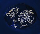
চিত্র:Dubaiworld.jpg

এই প্রাকদর্শনের আকার: ৭৮০ × ৫৯৯ পিক্সেল। অন্যান্য আকারসমূহ: ৩১২ × ২৪০ পিক্সেল | ৬২৫ × ৪৮০ পিক্সেল | ৯৯৯ × ৭৬৮ পিক্সেল | ১,২৮০ × ৯৮৪ পিক্সেল | ১,৩৩৫ × ১,০২৬ পিক্সেল।
পূর্ণ রেজোলিউশন (১,৩৩৫ × ১,০২৬ পিক্সেল, ফাইলের আকার: ৮১১ কিলোবাইট, এমআইএমই ধরন: image/jpeg)
ফাইলের ইতিহাস
যেকোনো তারিখ/সময়ে ক্লিক করে দেখুন ফাইলটি তখন কী অবস্থায় ছিল।
| তারিখ/সময় | সংক্ষেপচিত্র | মাত্রা | ব্যবহারকারী | মন্তব্য | |
|---|---|---|---|---|---|
| বর্তমান | ০৭:৫০, ২৭ নভেম্বর ২০০৯ |  | ১,৩৩৫ × ১,০২৬ (৮১১ কিলোবাইট) | Wikiarius | {{Information |Description={{en|1=The World Archipelago, Persian Gulf. The image shows the project on February 5, 2009. All the continents are represented (the “map” is tilted toward the left). A breakwater surrounds the archipelago, and its role is |
সংযোগসমূহ
নিচের পৃষ্ঠা(গুলো) থেকে এই ছবিতে সংযোগ আছে:
ফাইলের বৈশ্বিক ব্যবহার
নিচের অন্যান্য উইকিগুলো এই ফাইলটি ব্যবহার করে:
- ar.wikipedia.org-এ ব্যবহার
- arz.wikipedia.org-এ ব্যবহার
- ast.wikipedia.org-এ ব্যবহার
- ca.wikipedia.org-এ ব্যবহার
- ceb.wikipedia.org-এ ব্যবহার
- cs.wikipedia.org-এ ব্যবহার
- en.wikipedia.org-এ ব্যবহার
- eu.wikipedia.org-এ ব্যবহার
- fa.wikipedia.org-এ ব্যবহার
- fi.wikipedia.org-এ ব্যবহার
- fr.wikipedia.org-এ ব্যবহার
- he.wikipedia.org-এ ব্যবহার
- hu.wikipedia.org-এ ব্যবহার
- it.wikipedia.org-এ ব্যবহার
- ja.wikipedia.org-এ ব্যবহার
- ka.wikipedia.org-এ ব্যবহার
- lt.wikipedia.org-এ ব্যবহার
- mg.wikipedia.org-এ ব্যবহার
- nn.wikipedia.org-এ ব্যবহার
- pl.wikipedia.org-এ ব্যবহার
- pt.wikipedia.org-এ ব্যবহার
- ro.wikipedia.org-এ ব্যবহার
- ru.wikipedia.org-এ ব্যবহার
- sk.wikipedia.org-এ ব্যবহার
- sv.wikipedia.org-এ ব্যবহার
- ta.wikipedia.org-এ ব্যবহার
- uk.wikipedia.org-এ ব্যবহার
- vi.wikipedia.org-এ ব্যবহার
- www.wikidata.org-এ ব্যবহার
- zh.wikipedia.org-এ ব্যবহার


