
চিত্র:Dependent territories.svg

এই SVG ফাইলের জন্য এই PNG প্রাকদর্শনের আকার: ৮০০ × ৪০৬ পিক্সেল। অন্যান্য আকারসমূহ: ৩২০ × ১৬২ পিক্সেল | ৬৪০ × ৩২৫ পিক্সেল | ১,০২৪ × ৫২০ পিক্সেল | ১,২৮০ × ৬৫০ পিক্সেল | ২,৫৬০ × ১,৩০০ পিক্সেল | ২,৭৫৪ × ১,৩৯৮ পিক্সেল।
পূর্ণ রেজোলিউশন (এসভিজি ফাইল, সাধারণত ২,৭৫৪ × ১,৩৯৮ পিক্সেল, ফাইলের আকার: ১.০৫ মেগাবাইট)
| এই ফাইলটি উইকিমিডিয়া কমন্স থেকে নেওয়া। সেখানের বর্ণনা পাতার বিস্তারিত নিম্নে দেখানো হলো। (সম্পাদনা)
|
সারাংশ
| বিবরণ |
English:
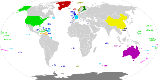
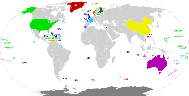
Dependent territories and their sovereign countries. All territories are labelled according to ISO 3166-1. Each territory in the United States Minor Outlying Islands is labelled UM- followed by the first letter of its name and another unique letter if needed. The following territories do not have ISO 3166-1 codes: 1: Akrotiri and Dhekelia 2: Ashmore and Cartier Islands 3: Coral Sea Islands Español: Los Territorios dependientes en el Mundo y los países soberanos de los que dependen.
Todos los territorios están etiquetados según la norma ISO 3166-1. Los siguientes territorios no tienen códigos ISO 3166-1: 1) Akrotiri y Dhekelia; 2) Islas Ashmore y Cartier; 3) Islas del Mar de CoralFrançais : Les territoires dépendants dans le monde et les pays souverains dont ils dépendent.
Tous les territoires sont labellisés selon la norme ISO 3166-1. Les territoires suivants n'ont pas de codes ISO 3166-1 : 1) Akrotiri et Dhekelia ; 2) Iles Ashmore et Cartier ; 3) Iles de la mer de CorailPortuguês: Os territórios dependentes no mundo e os países soberanos dos quais eles dependem.
Todos os territórios são rotulados de acordo com a norma ISO 3166-1. Os seguintes territórios não possuem códigos ISO 3166-1: 1) Akrotiri e Dhekelia; 2) Ashmore e Ilhas Cartier; 3) Ilhas do Mar de CorallDeutsch: Die abhängigen Gebiete in der Welt und die souveränen Länder, von denen sie abhängen.
Alle Gebiete sind gemäß ISO 3166-1 gekennzeichnet. Die folgenden Gebiete haben keine ISO 3166-1-Codes: 1) Akrotiri und Dhekelia; 2) Ashmore- und Cartier-Inseln; 3) Korallenmeerinseln |
| তারিখ | |
| উৎস | নিজের কাজ, based on BlankMap-World.svg |
| লেখক | Heitordp |
লাইসেন্স প্রদান
আমি, এই কাজের স্বত্বাধিকারী, এতদ্দ্বারা আমি এই কাজকে নিম্ন বর্ণিত লাইসেন্সের আওতায় প্রকাশ করলাম:
| এই ফাইলটি ক্রিয়েটিভ কমন্স সিসি০ ১.০ সার্বজনীন পাবলিক ডোমেইন উৎসর্গীকরণের আওতায় রয়েছে। | |
| যেই ব্যক্তিটি এই কাজটির সাথে সংশ্লিষ্ট তিনি এই কাজটি পাবলিক ডোমেইনে মুক্ত করার মাধ্যমে তাঁর সকল স্বত্ত্ব বিশ্বের সকল কপিরাইট আইনের আওতায় ত্যাগ করেছেন। যার মধ্যে নেইবারিং অধিকার, ও আইনের মাধ্যমে এক্সটেন্টও অন্তর্গত। আপনি এই কাজটি কোন অনুমতি চাওয়া ছাড়াই মুক্তভাবে অনুলিপি, পরিবর্তন, বিতরণ করতে পারেন, এবং এমন কি কোনো বাণিজ্যিক কাজেও ব্যবহার করতে পারেন।
|
ফাইলের ইতিহাস
যেকোনো তারিখ/সময়ে ক্লিক করে দেখুন ফাইলটি তখন কী অবস্থায় ছিল।
| তারিখ/সময় | সংক্ষেপচিত্র | মাত্রা | ব্যবহারকারী | মন্তব্য | |
|---|---|---|---|---|---|
| বর্তমান | ২২:৫৬, ২০ জুলাই ২০২০ | | ২,৭৫৪ × ১,৩৯৮ (১.০৫ মেগাবাইট) | M.Bitton | Added the missing border between Morocco and Western Sahara. |
| ২০:৫৮, ১২ জুলাই ২০২০ |  | ২,৭৫৪ × ১,৩৯৮ (১.০৫ মেগাবাইট) | Heitordp | Corrected code of Heard Island and McDonald Islands, and removed color from Taiwan | |
| ১২:১৩, ১২ জুলাই ২০২০ |  | ২,৭৫৪ × ১,৩৯৮ (১.০৮ মেগাবাইট) | Wiz9999 | Replacing XAD, XAC, and XCS with 1,2, and 3 to make the map more neutral. XAD, XAC, and XCS do not represent any formal labelling/classification system to describe Akrotiri and Dhekelia, Ashmore and Cartier Islands, and Coral Sea Islands outside of this file. | |
| ২২:০৫, ৭ জুলাই ২০২০ |  | ২,৭৫৪ × ১,৩৯৮ (১.০৫ মেগাবাইট) | Heitordp | Uploaded own work with UploadWizard |
সংযোগসমূহ
নিচের পৃষ্ঠা(গুলো) থেকে এই ছবিতে সংযোগ আছে:
ফাইলের বৈশ্বিক ব্যবহার
নিচের অন্যান্য উইকিগুলো এই ফাইলটি ব্যবহার করে:
- en.wikipedia.org-এ ব্যবহার
- eu.wikipedia.org-এ ব্যবহার
- mk.wikipedia.org-এ ব্যবহার
- pt.wikipedia.org-এ ব্যবহার
- tr.wikipedia.org-এ ব্যবহার