
চিত্র:Crimean Khanate 1600.gif
এর চেয়ে বেশি রেজোলিউশন লভ্য নয়।
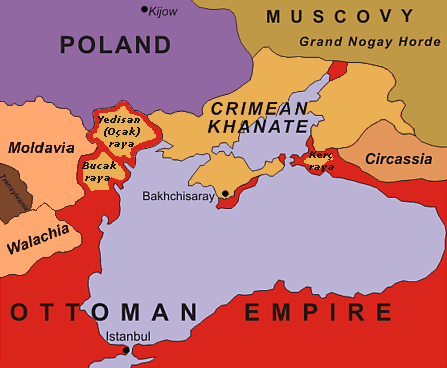
Crimean_Khanate_1600.gif (৪৪৭ × ৩৬৮ পিক্সেল, ফাইলের আকার: ২৩ কিলোবাইট, এমআইএমই ধরন: image/gif)
| এই ফাইলটি উইকিমিডিয়া কমন্স থেকে নেওয়া। সেখানের বর্ণনা পাতার বিস্তারিত নিম্নে দেখানো হলো। (সম্পাদনা)
|
| বিবরণ | original description: "Black Sea Region in 1600". No reference is given for the data shown in the map. |
| তারিখ | 13 February 2005 (uploaded to en-wiki as 1600.gif) |
| উৎস | অজানা |
| লেখক | Oleksa Haiworonski |
| অন্যান্য সংস্করণ | No labels, Turkish, Norwegian, Russian |

|
This historical map image could be re-created using vector graphics as an SVG file. This has several advantages; see Commons:Media for cleanup for more information. If an SVG form of this image is available, please upload it and afterwards replace this template with
{{vector version available|new image name}}.
It is recommended to name the SVG file “Crimean Khanate 1600.svg”—then the template Vector version available (or Vva) does not need the new image name parameter. |

|
The copyright holder of this work allows anyone to use it for any purpose including unrestricted redistribution, commercial use, and modification.
Usage notes:
|
ফাইলের ইতিহাস
যেকোনো তারিখ/সময়ে ক্লিক করে দেখুন ফাইলটি তখন কী অবস্থায় ছিল।
| তারিখ/সময় | সংক্ষেপচিত্র | মাত্রা | ব্যবহারকারী | মন্তব্য | |
|---|---|---|---|---|---|
| বর্তমান | ১৮:০৭, ৪ জুলাই ২০১৫ | | ৪৪৭ × ৩৬৮ (২৩ কিলোবাইট) | Spiridon Ion Cepleanu | Yedisan, Budzak & Kertch : ottoman territories with tatar autonomous settlements. |
| ১৫:৫৬, ২০ অক্টোবর ২০১০ |  | ৪৪৭ × ৩৬৮ (২৬ কিলোবাইট) | Liandrei | Removed watermark and border | |
| ১৩:১১, ৫ মে ২০০৮ |  | ৪৫০ × ৩৭১ (২৭ কিলোবাইট) | Kjetil r | Removing "Ulus of Gazi", I can't find any reference to this nation, it seems like this area was part of the Crimean Khanate | |
| ১৮:২১, ২২ জানুয়ারি ২০০৬ |  | ৪৫০ × ৩৭১ (২৮ কিলোবাইট) | Hardscarf | Crimean Khanate around 1600 From [http://en.wikipedia.org/wiki/Image:1600.gif english wikipedia] by [http://en.wikipedia.org/wiki/User_talk:Oleksa Oleksa] Original discription: Black Sea Region in 1600 Definition licence: ''Created: Oleksa Haiworon |
সংযোগসমূহ
নিচের পৃষ্ঠা(গুলো) থেকে এই ছবিতে সংযোগ আছে:
ফাইলের বৈশ্বিক ব্যবহার
নিচের অন্যান্য উইকিগুলো এই ফাইলটি ব্যবহার করে:
- ar.wikipedia.org-এ ব্যবহার
- azb.wikipedia.org-এ ব্যবহার
- br.wikipedia.org-এ ব্যবহার
- bs.wikipedia.org-এ ব্যবহার
- ca.wikipedia.org-এ ব্যবহার
- ckb.wikipedia.org-এ ব্যবহার
- cs.wikipedia.org-এ ব্যবহার
- da.wikipedia.org-এ ব্যবহার
- de.wikipedia.org-এ ব্যবহার
- el.wikipedia.org-এ ব্যবহার
- en.wikipedia.org-এ ব্যবহার
- en.wiktionary.org-এ ব্যবহার
- eo.wikipedia.org-এ ব্যবহার
- es.wikipedia.org-এ ব্যবহার
- et.wikipedia.org-এ ব্যবহার
- eu.wikipedia.org-এ ব্যবহার
- fa.wikipedia.org-এ ব্যবহার
- fr.wikipedia.org-এ ব্যবহার
- gl.wikipedia.org-এ ব্যবহার
- hi.wikipedia.org-এ ব্যবহার
- hu.wikipedia.org-এ ব্যবহার
- incubator.wikimedia.org-এ ব্যবহার
এই ফাইলের অন্যান্য বৈশ্বিক ব্যবহার দেখুন।