
চিত্র:Choctaw-Nation.png

এই প্রাকদর্শনের আকার: ৪৮৬ × ৬০০ পিক্সেল। অন্যান্য আকারসমূহ: ১৯৪ × ২৪০ পিক্সেল | ৩৮৯ × ৪৮০ পিক্সেল | ৯৮৭ × ১,২১৮ পিক্সেল।
পূর্ণ রেজোলিউশন (৯৮৭ × ১,২১৮ পিক্সেল, ফাইলের আকার: ৪৬ কিলোবাইট, এমআইএমই ধরন: image/png)
| এই ফাইলটি উইকিমিডিয়া কমন্স থেকে নেওয়া। সেখানের বর্ণনা পাতার বিস্তারিত নিম্নে দেখানো হলো। (সম্পাদনা)
|

|
This locator map image could be re-created using vector graphics as an SVG file. This has several advantages; see Commons:Media for cleanup for more information. If an SVG form of this image is available, please upload it and afterwards replace this template with
{{vector version available|new image name}}.
It is recommended to name the SVG file “Choctaw-Nation.svg”—then the template Vector version available (or Vva) does not need the new image name parameter. |
সারাংশ
| বিবরণ |
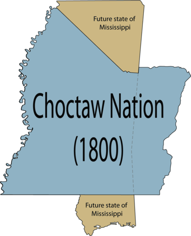
English: Map of the maximum extent of the conquests of the Choctaw tribe in 1800 before land cessions in relation to the U.S. state of Mississippi. |
| তারিখ | |
| উৎস | নিজের কাজ |
| লেখক | Rob (talk) |
লাইসেন্স প্রদান
| এই কাজের প্রণেতা ইংরেজি উইকিপিডিয়া-এর Robfergusonjr কাজটি পাবলিক ডোমেইনে প্রকাশ করেছেন। এটি বিশ্বব্যাপী প্রযোজ্য হবে। কিছু দেশে এটি আইনত সিদ্ধ নাও হতে পারে, যদি তাই হয়: Robfergusonjr যে-কাউকে যেকোনো উদ্দেশ্যে, বিনাশর্তে এই কাজটি ব্যবহারের অনুমতি প্রদান করেন, যদি না সেই শর্তগুলো আইনত প্রয়োজনীয় হয়। |
মূল আপলোড লগ
মূল বিবরণ পাতাটি এখানে ছিল। নিম্নলিখিত সকল ব্যবহারকারীর নাম en.wikipedia-এ উল্লেখ করা ছিল।
- 2008-04-23 19:46 Robfergusonjr 987×1218×8 (30444 bytes) {{Information |Description= Map of the complete Choctaw Nation in 1800 before land cessions in relation to the U.S. state of Mississippi. |Source=self-made |Date=April 23, 2008 |Author=~~~ |other_versions= }}
ফাইলের ইতিহাস
যেকোনো তারিখ/সময়ে ক্লিক করে দেখুন ফাইলটি তখন কী অবস্থায় ছিল।
| তারিখ/সময় | সংক্ষেপচিত্র | মাত্রা | ব্যবহারকারী | মন্তব্য | |
|---|---|---|---|---|---|
| বর্তমান | ১০:৩৮, ১৮ জানুয়ারি ২০১২ | | ৯৮৭ × ১,২১৮ (৪৬ কিলোবাইট) | Sreejithk2000 | Removed white background |
| ২৩:৫১, ১৫ মে ২০০৮ |  | ৯৮৭ × ১,২১৮ (৩০ কিলোবাইট) | Legoktm | {{BotMoveToCommons|en.wikipedia}} {{Information |Description={{en|Map of the complete Choctaw Nation in 1800 before land cessions in relation to the U.S. state of Mississippi.}} |Source=Transferred from [http://en.wikipedia.org en.wikipedia]<br/> (Origi |
সংযোগসমূহ
নিচের পৃষ্ঠা(গুলো) থেকে এই ছবিতে সংযোগ আছে:
ফাইলের বৈশ্বিক ব্যবহার
নিচের অন্যান্য উইকিগুলো এই ফাইলটি ব্যবহার করে:
- arz.wikipedia.org-এ ব্যবহার
- ca.wikipedia.org-এ ব্যবহার
- de.wikipedia.org-এ ব্যবহার
- en.wikipedia.org-এ ব্যবহার
- es.wikipedia.org-এ ব্যবহার
- fr.wikipedia.org-এ ব্যবহার
- ja.wikipedia.org-এ ব্যবহার
- la.wikipedia.org-এ ব্যবহার