চিত্র:Chariot spread.png

পাতাটির বিষয়বস্তু অন্যান্য ভাষায় নেই।
এই ফাইলটি উইকিমিডিয়া কমন্স থেকে নেওয়া। মূল পাতাটি দেখতে ক্লিক করুন।
উইকিপিডিয়া, মুক্ত বিশ্বকোষ থেকে

Chariot_spread.png(৪০০ × ২৩১ পিক্সেল, ফাইলের আকার: ১৫৪ কিলোবাইট, এমআইএমই ধরন: image/png)

এই ফাইলটি উইকিমিডিয়া কমন্স থেকে নেওয়া। সেখানের বর্ণনা পাতার বিস্তারিত নিম্নে দেখানো হলো। (সম্পাদনা)
উইকিমিডিয়া কমন্স, মুক্ত লাইসেন্সযুক্ত মিডিয়ার একটি ভান্ডার। আপনি সাহায্য করতে পারেন
বিবরণ

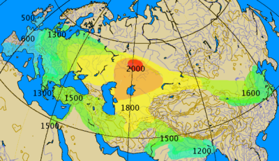
Historical spread of the chariot. This map combines various classes of information, historical and archaeological. The 'isochrones' as given should not be considered more than rough approximations, give or take a century.

  • red, 2000 BC: area of the earliest known spoke-wheeled chariots (Sintashta-Petrovka culture)
  • orange, 1900 BC: extent of the Andronovo culture, expanding from its early Sintashta-Petrovka phase; spread of technology in this area would have been unimpeded and practically instantaneous
  • yellow, 1800 BC: extent of the great steppes and semi-deserts of Central Asia, approximate extent of the early Indo-Iranian diaspora at that time. Note that early examples of chariots appear in Anatolia as early as around this time.
  • light green, 1700 BC: unknown, early period of spread beyond the steppes
  • green/cyan, 1600-1200 BC: the Kassite period in Mesopotamia, rise to notability of the chariot in the Ancient Near East, introduction to China, possibly also to the Punjab and the Gangetic plain (Rigveda) and E and N Europe (Trundholm Sun Chariot), assumed spread of the chariot as part of Late Bronze Age technology
  • blue, 1000-500 BC: Iron Age spread of the chariot to W Europe by Celtic migrations
তারিখ
উৎস নিজের কাজ by by en:User:Dbachmann
লেখক by en:User:Dbachmann
অনুমতি
(এ ফাইলের পুনঃব্যবহার)
GNU head এই নথি অনুলিপি, বিতরণ এবং/বা পরিবর্তন করার অনুমতি ফ্রি সফটওয়্যার ফাউন্ডেশন কর্তৃক প্রকাশিত গনু ফ্রি ডকুমেন্টেশন লাইসেন্স, সংস্করণ ১.২ বা তার পরবর্তী সংস্করণের আওতায় অনুমতিপ্রাপ্ত; যে কোনো রকম অনুচ্ছেদ পরিবর্তন, সম্মুখ-প্রচ্ছদের লেখা, পিছন-প্রচ্ছদের লেখা পরিবর্তন করা ছাড়াই। এই লাইসেন্সের একটি অনুলিপি গনু ফ্রি ডকুমেন্টেশন লাইসেন্স শিরোনামের অনুচ্ছেদে অন্তর্ভুক্ত করা আছে।
w:bn:ক্রিয়েটিভ কমন্স
স্বীকৃতিপ্রদান একইভাবে বণ্টন
এই ফাইলটি ক্রিয়েটিভ কমন্স অ্যাট্রিবিউশন-শেয়ার অ্যালাইক ৩.০ আনপোর্টেড লাইসেন্সের আওতায় লাইসেন্সকৃত।
আপনি স্বাধীনভাবে:
  • বণ্টন করতে পারেন – এ কাজটি অনুলিপি, বিতরণ এবং প্রেরণ করতে পারেন
  • পুনঃমিশ্রণ করতে পারেন – কাজটি অভিযোজন করতে পারেন
নিম্নের শর্তাবলীর ভিত্তিতে:
  • স্বীকৃতিপ্রদান – আপনাকে অবশ্যই যথাযথ স্বীকৃতি প্রদান করতে হবে, লাইসেন্সের একটি লিঙ্ক সরবরাহ করতে হবে এবং কোনো পরিবর্তন হয়েছে কিনা তা নির্দেশ করতে হবে। আপনি যেকোনো যুক্তিসঙ্গত পদ্ধতিতে এটি করতে পারেন। কিন্তু এমন ভাবে নয়, যাতে প্রকাশ পায় যে লাইসেন্সধারী আপনাকে বা আপনার এই ব্যবহারের জন্য অনুমোদন দিয়েছে।
  • একইভাবে বণ্টন – আপনি যদি কাজটি পুনঃমিশ্রণ, রুপান্তর, বা এর ওপর ভিত্তি করে নতুন সৃষ্টিকর্ম তৈরি করেন, তবে আপনাকে অবশ্যই আপনার অবদান একই লাইসেন্স বা একই রকমের লাইসেন্সের আওতায় বিতরণ করতে হবে।
এই লাইসেন্স ট্যাগটি জিএফডিএল লাইসেন্স হালনাগাদের অংশ হিসেবে এই ফাইলে সংযুক্ত হয়েছে।
অন্যান্য সংস্করণ
This historical map image could be re-created using vector graphics as an SVG file. This has several advantages; see Commons:Media for cleanup for more information. If an SVG form of this image is available, please upload it and afterwards replace this template with {{vector version available|new image name}}.


It is recommended to name the SVG file “Chariot spread.svg”—then the template Vector version available (or Vva) does not need the new image name parameter.

ক্যাপশন

এই ফাইল কি প্রতিনিধিত্ব করছে তার এক লাইন ব্যাখ্যা যোগ করুন

এই ফাইলে চিত্রিত আইটেমগুলি

যা চিত্রিত করে

checksum ইংরেজি

১,৫৭,৮৯২ বাইট

২৩১ পিক্সেল

৪০০ পিক্সেল

ফাইলের ইতিহাস

যেকোনো তারিখ/সময়ে ক্লিক করে দেখুন ফাইলটি তখন কী অবস্থায় ছিল।

তারিখ/সময়সংক্ষেপচিত্রমাত্রাব্যবহারকারীমন্তব্য
বর্তমান০৪:০০, ২৭ সেপ্টেম্বর ২০২১০৪:০০, ২৭ সেপ্টেম্বর ২০২১-এর সংস্করণের সংক্ষেপচিত্র৪০০ × ২৩১ (১৫৪ কিলোবাইট)GPinkertonReverted to version as of 14:14, 17 August 2005 (UTC) COM:CROP
১৯:২৮, ২ মে ২০২১১৯:২৮, ২ মে ২০২১-এর সংস্করণের সংক্ষেপচিত্র৪০০ × ২৩১ (১৬১ কিলোবাইট)Claude ZygielNorth Africa too (Raymond Vaufrey, Préhistoire de l'Afrique, tome II, Service des Publications de l'Université de Tunis, 1969)
১৪:১৪, ১৭ আগস্ট ২০০৫১৪:১৪, ১৭ আগস্ট ২০০৫-এর সংস্করণের সংক্ষেপচিত্র৪০০ × ২৩১ (১৫৪ কিলোবাইট)Dbachmanncorrection, labels
০৭:১৪, ১৭ আগস্ট ২০০৫০৭:১৪, ১৭ আগস্ট ২০০৫-এর সংস্করণের সংক্ষেপচিত্র৩৫০ × ২০২ (১১৯ কিলোবাইট)Dbachmann by en:User:Dbachmann {{GFDL}}

নিচের পৃষ্ঠা(গুলো) থেকে এই ছবিতে সংযোগ আছে:

ফাইলের বৈশ্বিক ব্যবহার

নিচের অন্যান্য উইকিগুলো এই ফাইলটি ব্যবহার করে:

এই ফাইলের অন্যান্য বৈশ্বিক ব্যবহার দেখুন।

অধি-উপাত্ত