
চিত্র:AMH-8133-KB Floor plan of the fort on Goeree.jpg

এই প্রাকদর্শনের আকার: ৭১৮ × ৬০০ পিক্সেল। অন্যান্য আকারসমূহ: ২৮৮ × ২৪০ পিক্সেল | ৫৭৫ × ৪৮০ পিক্সেল | ৯২০ × ৭৬৮ পিক্সেল | ১,২২৬ × ১,০২৪ পিক্সেল | ২,৪০০ × ২,০০৪ পিক্সেল।
পূর্ণ রেজোলিউশন (২,৪০০ × ২,০০৪ পিক্সেল, ফাইলের আকার: ৮০৮ কিলোবাইট, এমআইএমই ধরন: image/jpeg)
| এই ফাইলটি উইকিমিডিয়া কমন্স থেকে নেওয়া। সেখানের বর্ণনা পাতার বিস্তারিত নিম্নে দেখানো হলো। (সম্পাদনা)
|
সারাংশ
Nederlands: Plattegrond van het fort op Goeree
English: Floor plan of the fort on Goeree( |
|||||||||||||||||||||||||||
|---|---|---|---|---|---|---|---|---|---|---|---|---|---|---|---|---|---|---|---|---|---|---|---|---|---|---|---|
| লেখক |
Nederlands: Anoniem / Anonymous (landmeter / kaartenmaker), Awnsham Churchill (uitgever), John Churchill (uitgever)
English: Anoniem / Anonymous (land surveyor / mapmaker), Awnsham Churchill (publisher), John Churchill (publisher) |
||||||||||||||||||||||||||
| শিরোনাম |
Nederlands: Plattegrond van het fort op Goeree
English: Floor plan of the fort on Goeree |
||||||||||||||||||||||||||
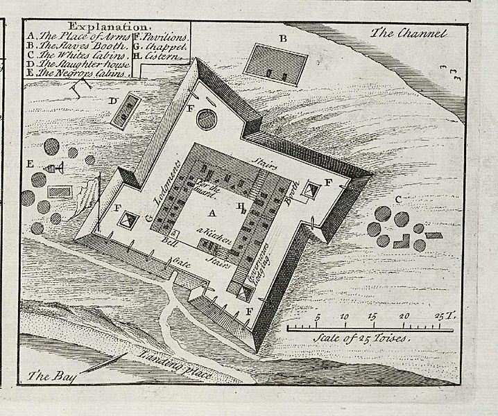
| বিবরণ |
Nederlands: Plattegrond van het fort op Goeree.
Legenda: A-H. Tot 1677 was het eiland Goeree in Nederlandse handen, daarna ging het over naar Frankrijk.English: Floor plan of the fort on the island of Goeree.
Key: A-H. Until 1677 the island of Goeree was held by the Dutch, thereafter it went to France. |
||||||||||||||||||||||||||
| তারিখ | ১৭৩২ | ||||||||||||||||||||||||||
| মধ্যম |
Nederlands: gravure op papier
English: engraving on paper |
||||||||||||||||||||||||||
| আকার | উচ্চতা: ১০.৫ সে.মি.; প্রস্থ: ৯.০ সে.মি. | ||||||||||||||||||||||||||
| সংগ্রহ |
|
||||||||||||||||||||||||||
| সংযোজন সংখ্যা |
61 B 25, na p. 20 |
||||||||||||||||||||||||||
| টীকা |
English: Subjects: chart / map / plan, key, fortification, building, ship / vessel
Nederlands: Onderwerpen: plattegrond / kaart, legenda, vesting, gebouw, schip / vaartuig |
||||||||||||||||||||||||||
| উৎস/আলোকচিত্রগ্রাহক |
|
||||||||||||||||||||||||||
| অনুমতি (এ ফাইলের পুনঃব্যবহার) |
|
||||||||||||||||||||||||||

| বস্তুর অবস্থান | | এটি এবং অন্যান্য ছবি তাদের অবস্থানের উপর: ওপেনস্ট্রিটম্যাপ |
|---|
ফাইলের ইতিহাস
যেকোনো তারিখ/সময়ে ক্লিক করে দেখুন ফাইলটি তখন কী অবস্থায় ছিল।
| তারিখ/সময় | সংক্ষেপচিত্র | মাত্রা | ব্যবহারকারী | মন্তব্য | |
|---|---|---|---|---|---|
| বর্তমান | ১৫:৩১, ১০ জুন ২০১৪ | | ২,৪০০ × ২,০০৪ (৮০৮ কিলোবাইট) | HuskyBot | == {{int:filedesc}} == {{Artwork |title = {{nl|1=Plattegrond van het fort op Goeree}} {{en|1=Floor plan of the fort on Goeree}} |description = {{nl|1=Plattegrond van het fort op Goeree. Legenda: ''A-H''. Tot... |
সংযোগসমূহ
নিচের পৃষ্ঠা(গুলো) থেকে এই ছবিতে সংযোগ আছে:
ফাইলের বৈশ্বিক ব্যবহার
নিচের অন্যান্য উইকিগুলো এই ফাইলটি ব্যবহার করে:
- el.wikipedia.org-এ ব্যবহার
- en.wikipedia.org-এ ব্যবহার
- nn.wikipedia.org-এ ব্যবহার
- tum.wikipedia.org-এ ব্যবহার