
চিত্র:1827 Finley Map of Vermont - Geographicus - Vermont-finely-1827.jpg

এই প্রাকদর্শনের আকার: ৪৭১ × ৬০০ পিক্সেল। অন্যান্য আকারসমূহ: ১৮৮ × ২৪০ পিক্সেল | ৩৭৭ × ৪৮০ পিক্সেল | ৬০৩ × ৭৬৮ পিক্সেল | ৮০৪ × ১,০২৪ পিক্সেল | ২,৩৫৬ × ৩,০০০ পিক্সেল।
পূর্ণ রেজোলিউশন (২,৩৫৬ × ৩,০০০ পিক্সেল, ফাইলের আকার: ১.৭৮ মেগাবাইট, এমআইএমই ধরন: image/jpeg)
| এই ফাইলটি উইকিমিডিয়া কমন্স থেকে নেওয়া। সেখানের বর্ণনা পাতার বিস্তারিত নিম্নে দেখানো হলো। (সম্পাদনা)
|
| Anthony Finley: Vermont.
( |
||||||||||||||
|---|---|---|---|---|---|---|---|---|---|---|---|---|---|---|
| শিল্পী |
|
|||||||||||||
| শিরোনাম |
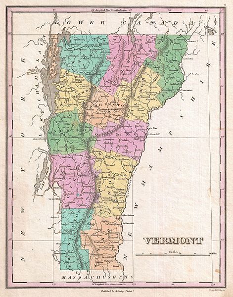
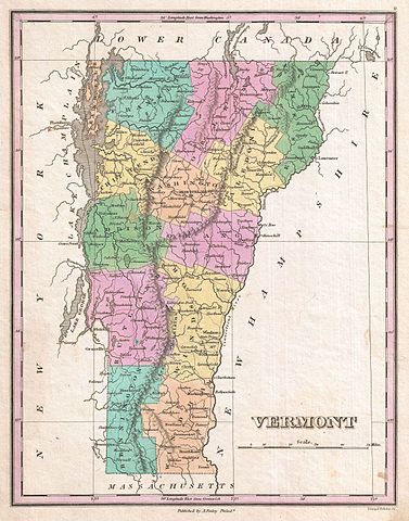
Vermont. |
|||||||||||||
| বিবরণ |
English: A beautiful example of Finley's important 1827 map of Vermont. Depicts the state with moderate detail in Finley's classic minimalist style. Shows river ways, roads, canals, and some topographical features. Offers color coding at the county level. Title and scale in lower right quadrant. It is very uncommon to find an early 19th century exclusively depicting Vermont, as most maps of the period bundled it with New Hampshire. Identifies Killington Peak and Camel's Hump, now popular ski resorts. Engraved by Young and Delleker for the 1827 edition of Anthony Finley's General Atlas . |
|||||||||||||
| তারিখ | ১৮২৭ (undated) | |||||||||||||
| আকার | উচ্চতা: ১১.৫ ইঞ্চি (২৯.২ সে.মি.); প্রস্থ: ৯.০ ইঞ্চি (২২.৮ সে.মি.) | |||||||||||||
| সংযোজন সংখ্যা |
Geographicus link: Vermont-finely-1827 |
|||||||||||||
| উৎস/আলোকচিত্রগ্রাহক |
Finley, Anthony, A New General Altas, Comprising a Complete Set of Maps, representing the Grand Divisions of the Globe, Together with the several Empires, Kingdoms and States in the World; Compiled from the Best Authorities, and corrected by the Most Recent Discoveries, Philadelphia, 1827.
|
|||||||||||||
| অনুমতি (এ ফাইলের পুনঃব্যবহার) |
|
|||||||||||||
ফাইলের ইতিহাস
যেকোনো তারিখ/সময়ে ক্লিক করে দেখুন ফাইলটি তখন কী অবস্থায় ছিল।
| তারিখ/সময় | সংক্ষেপচিত্র | মাত্রা | ব্যবহারকারী | মন্তব্য | |
|---|---|---|---|---|---|
| বর্তমান | ০৮:৫৫, ২৩ মার্চ ২০১১ | | ২,৩৫৬ × ৩,০০০ (১.৭৮ মেগাবাইট) | BotMultichillT | {{subst:User:Multichill/Geographicus |link=http://www.geographicus.com/P/AntiqueMap/Vermont-finely-1827 |product_name=1827 Finley Map of Vermont |map_title=Vermont. |description=A beautiful example of Finley's important 1827 map of Vermont. Depicts the st |
সংযোগসমূহ
নিচের পৃষ্ঠা(গুলো) থেকে এই ছবিতে সংযোগ আছে:
ফাইলের বৈশ্বিক ব্যবহার
নিচের অন্যান্য উইকিগুলো এই ফাইলটি ব্যবহার করে:
- en.wikipedia.org-এ ব্যবহার
- ja.wikipedia.org-এ ব্যবহার
- ko.wikipedia.org-এ ব্যবহার
- uk.wikipedia.org-এ ব্যবহার