মোয়াব
মোয়াব রাজ্য 𐤌𐤀𐤁 | |
|---|---|
| আনু. খ্রীষ্টপূর্ব ১৩শ শতাব্দী – আনু. ৪০০ খ্রীষ্টপূর্বাব্দ | |
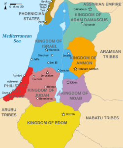
 খ্রীষ্টপূর্ব ৮৩০ অব্দের দিকে অঞ্চলটির একটি তাত্ত্বিক মানচিত্র। এতে মোয়াব রাজ্যকে অর্ণোন ও সেরদ নদীর মাঝে রক্তবেগুনী রঙে চিহ্নিত রয়েছে। | |
| অবস্থা | রাজতন্ত্র |
| রাজধানী | দীবোন |
| প্রচলিত ভাষা | মোয়াবীয় |
| ইতিহাস | |
• প্রতিষ্ঠা | আনু. খ্রীষ্টপূর্ব ১৩শ শতাব্দী |
• Collapsed | আনু. ৪০০ খ্রীষ্টপূর্বাব্দ |
| বর্তমানে যার অংশ | যর্দন |
| |||||
| mwjbw "Moab" চিত্রলিপিতে |
|---|

মোয়াব (মোয়াবীয়: 𐤌𐤀𐤁 Māʾab; হিব্রু: מוֹאָב, আধুনিক: Mō'av, টিবেরীয়: Mōʾāḇ; প্রাচীন গ্রিক: Μωάβ Mōáb; অশূরীয়: 𒈬𒀪𒁀𒀀𒀀 Mu'aba, 𒈠𒀪𒁀𒀀𒀀
Ma'ba, 𒈠𒀪𒀊 Ma'ab; মিসরীয়: 𓈗𓇋𓃀𓅱𓈉 Mū'ībū) হল একটি প্রাচীন রাজ্যের নাম যার এলাকা এখনকার আধুনিক যর্দন রাষ্ট্রে অবস্থিত। ভূমিটি পাহাড়ি এবং মৃত সাগরের পূর্ব তীরের অনেকাংশে অবস্থিত। মোয়াব রাজ্যের অস্তিত্ব অসংখ্য প্রত্নতাত্ত্বিক গবেষণার দ্বারা প্রমাণিত, বিশেষ করে মেশা স্টেল, যা ইস্রায়েল রাজ্যের রাজা ওমরির এক নামহীন ছেলের উপর মোয়াবীয় বিজয়ের বর্ণনা দেয়, একটি পর্ব যা ২ রাজাবলিতেও উল্লেখিত হয়েছে।[১] মোয়াবীয় রাজধানী ছিল দীবোন। ইব্রীয় ধর্মপুস্তক অনুসারে, মোয়াব প্রায়ই পশ্চিমদিকে তার ইস্রায়েলীয় প্রতিবেশীদের সঙ্গে বিরোধে লিপ্ত ছিল।[২][৩][৪]
তথ্যসূত্র[সম্পাদনা]
- ↑ 2 Kings
- ↑ Leyden (১৯০৪)। Verhandlungen des Zwölften Internationalen Orientalisten-Congresses। পৃষ্ঠা 261।
- ↑ comp. 1 Macc; Josephus, Jewish Antiquities xiii. 13, § 5; xiv. 1, § 4.
- ↑ Miller, Max (১৯৯৭)। "Ancient Moab: Still Largely Unknown"। George Ernest Wright; Frank Moore Cross; Edward Fay Campbell। The Biblical Archaeologist। 60। American Schools of Oriental Research। পৃষ্ঠা 194–204। জেস্টোর 3210621।
Among the travellers who traversed the whole Moabite plateau including Moab proper prior to 1870 and whose published observations deserve special mention are Ulrich Seetzen (1805), Ludwig Burckhardt (1812), Charles Irby and James Mangles (1818), and Louis de Saulcy (1851). Both Seetzen and Burckhardt died during the course of their travels, and their travel journals were edited and published posthumously by editors who did not always understand the details. Burckhardt's journal was published first, in 1822, and served as the basis for the Moab segment of Edward Robinson's map of Palestine published in 1841. Robinson's map depicts several strange features for the Moab segment, most of which can be traced to editorial mistakes in Burckhardt's journal and/or to entirely understandable misinterpretations of the journal on Robinson's part. Unfortunately, these strange features would linger on in maps of Palestine throughout the nineteenth century.
