টেমপ্লেট:তথ্যছক ভূমিকম্প
Usage[সম্পাদনা]
{{Infobox earthquake
|title              =
|image              =
|image alt          =
|imagecaption       =
|map                =
|map alt            =
|image name         =
|map2               =
|mapsize            =
|caption            =
|date               = <!-- {{Start-date|any date with or without time, any format}} -->
|origintime         =
|duration           =
|magnitude          = <!-- NNN [[Moment magnitude scale|M<sub>w</sub>]] -->
|depth              = <!-- {{convert|NNN|km|mi|0|abbr=on}} -->
|location           = <!-- {{coord|XXXXX|region:XX_type:event|display=inline,title}} -->
|type               =
|countries affected =
|damage             =
|intensity          =
|PGA                = <!-- NN''[[Peak ground acceleration|g]]'' -->
|tsunami            =
|landslide          =
|aftershocks        =
|casualties         =
}}
Examples[সম্পাদনা]
 Effects of the earthquake on the Pan-American Highway between Ica and Lima | |
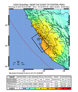
 Map of the Peru coastline, showing location and strength of quake. Star marks epicenter. | |
| ইউটিসি সময় | ?? |
|---|---|
| তারিখ * | ১৫ আগস্ট ২০০৭ |
| মূল সময় * | 23:40:57 UTC 18:40:57 PET |
| স্থায়িত্ব | 3 minutes |
| মাত্রা | 8.0 Mw |
| গভীরতা | ৩৯ কিমি (২৪ মা) |
| ভূকম্পন বিন্দু | ১৩°২১′১৪″ দক্ষিণ ৭৬°৩০′৩২″ পশ্চিম / ১৩.৩৫৪° দক্ষিণ ৭৬.৫০৯° পশ্চিম |
| ক্ষতিগ্রস্ত এলাকা | Peru |
| সুনামি | flooded part of Lima's Costa Verde highway, and much of Pisco's shore |
| হতাহত | 519 confirmed dead 1,366 injured |
| * Deprecated | See documentation. |
{{Infobox earthquake
|title              = 2007 Peru earthquake
|image              = 38 - Tremblement de terre - Août 2007.JPG
|image alt          = Effects of the earthquake on the Pan-American Highway between Ica and Lima
|imagecaption       = Effects of the earthquake on the Pan-American Highway between Ica and Lima
|map                = Peru Quake Aug 15-2007.jpg
|map alt            = The quake's center was near the coast of central Peru; the closest settlements were Imperial and Chincha Alta. The damage zone went about 100 km inland and north, and about 200 km south.
|image name         = <small>Map of the Peru coastline, showing location and strength of quake. Star marks [[epicenter]].</small>
|date               = {{Start-date|15 August 2007}}
|origintime         = 23:40:57 [[UTC]]<br/> 18:40:57 [[Time in Peru|PET]]
|duration           = 3 minutes
|magnitude          = 8.0 [[Moment magnitude scale|M<sub>w</sub>]]
|depth              = {{convert|39|km|mi|0|abbr=on}}
|location           = {{coord|13.354|S|76.509|W|region:PE_type:event|display=inline,title}}
|countries affected = [[Peru]]
|tsunami            = flooded part of Lima's Costa Verde highway, and much of Pisco's shore
|casualties         = 519 confirmed dead<br /> 1,366 injured
}}
Microformat[সম্পাদনা]
এই টেমপ্লেট দ্বারা উৎপাদিত এইচটিএমএল মার্ক-আপে একটি hCalendar মাইক্রোবিন্যাস অন্তর্ভুক্ত, যা কম্পিউটার প্রোগ্রাম দ্বারা event details সহজেই পার্সেবল করে তোলে। এটি নিবন্ধের তালিকাভুক্তকরণ এবং ডাটাবেজের রক্ষণাবেক্ষণের মতো কাজগুলোয় সহায়তা করে। উইকিপিডিয়ায় মাইক্রোবিন্যাস ব্যবহার সম্পর্কে আরও তথ্যের জন্য, অনুগ্রহ করে উইকিপিডিয়া:উইকিপ্রকল্প মাইক্রোবিন্যাস দেখুন।- ব্যবহৃত অ্যাট্রিবিউট
এই মাইক্রোবিন্যাসটি এইচটিএমএল অ্যাট্রিবিউটের মধ্যে রয়েছে::
- attendee
- contact
- description
- dtend
- dtstart
- location
- organiser
- summary
- url
- vevent
অনুগ্রহ করে এই অ্যাট্রিবিউটের নাম পরিবর্তন বা অপসারণ করবেন না
অথবা নেস্টেড উপাদান ব্যবহার করবেন না, যা ভেঙ্গে যায়।
অথবা নেস্টেড উপাদান ব্যবহার করবেন না, যা ভেঙ্গে যায়।
| উপরোক্ত নথিটি টেমপ্লেট:তথ্যছক ভূমিকম্প/নথি থেকে প্রতিলিপ্ত। (সম্পাদনা | ইতিহাস) ব্যবহারকারীগণ খেলাঘর (তৈরি করুন | আয়না) এবং পরীক্ষা পাতায় (তৈরি করুন) এই টেমপ্লেট সংক্রান্ত পরীক্ষা-নিরীক্ষা করতে পারেন। দয়া করে /নথি উপপাতায় বিষয়শ্রেণী যোগ করুন। এই টেমপ্লেটের উপপাতাসমূহ। |
