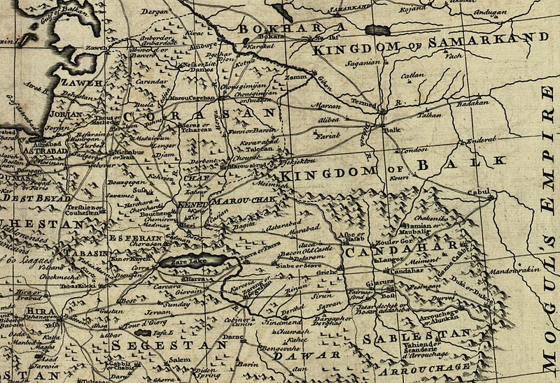
চিত্র:Map of Afghanistan during the Safavid and Moghul Empire.jpg
অবয়ব

এই প্রাকদর্শনের আকার: ৮০০ × ৫৪৮ পিক্সেল। অন্যান্য আকারসমূহ: ৩২০ × ২১৯ পিক্সেল | ৬৪০ × ৪৩৯ পিক্সেল | ১,০২৪ × ৭০২ পিক্সেল | ১,২৮০ × ৮৭৮ পিক্সেল | ২,৫৩২ × ১,৭৩৬ পিক্সেল।
পূর্ণ রেজোলিউশন (২,৫৩২ × ১,৭৩৬ পিক্সেল, ফাইলের আকার: ১.১৬ মেগাবাইট, এমআইএমই ধরন: image/jpeg)
ফাইলের ইতিহাস
যেকোনো তারিখ/সময়ে ক্লিক করে দেখুন ফাইলটি তখন কী অবস্থায় ছিল।
| তারিখ/সময় | সংক্ষেপচিত্র | মাত্রা | ব্যবহারকারী | মন্তব্য | |
|---|---|---|---|---|---|
| বর্তমান | ০২:৫০, ২ মার্চ ২০১১ |  | ২,৫৩২ × ১,৭৩৬ (১.১৬ মেগাবাইট) | Officer | {{Information |Description= |Source= |Date= |Author= |Permission= |other_versions= }} |
| ০২:৪২, ২ মার্চ ২০১১ |  | ২,৩৪২ × ১,৬৮২ (১.০৪ মেগাবাইট) | Officer | {{Information |Description= |Source= |Date= |Author= |Permission= |other_versions= }} | |
| ০২:৩২, ২ মার্চ ২০১১ |  | ২,৪০২ × ১,৫৯৯ (১.০২ মেগাবাইট) | Officer | {{Information |Description= |Source= |Date= |Author= |Permission= |other_versions= }} | |
| ০১:৩৭, ২ মার্চ ২০১১ |  | ২,০৬৪ × ১,৬০৭ (৮৫৬ কিলোবাইট) | Officer | {{Information |Description= |Source= |Date= |Author= |Permission= |other_versions= }} | |
| ১৪:৩৯, ১২ মার্চ ২০১০ |  | ১,৮১০ × ১,৮১০ (৯১৫ কিলোবাইট) | Officer | {{Information |Description=Map of Afghanistan during the Safavid and Mughal Empire, from the 16th century to 1747 when the current nation-state was created. |Source=[http://memory.loc.gov/ The Library of Congress, American Memory] - [http://memory.loc.gov | |
| ০৩:৪৮, ২১ জানুয়ারি ২০১০ |  | ২,০৫৬ × ১,৫৭৪ (৯৮৩ কিলোবাইট) | Officer | {{Information |Description=Map of Afghanistan during the Safavid and Mughal Empire, from the 16th century to 1747 when the current nation-state was created. |Source=[http://memory.loc.gov/ The Library of Congress, American Memory] - [http://memory.loc.gov | |
| ০১:২৯, ১৯ নভেম্বর ২০০৯ |  | ১,৬৭৯ × ১,৬৭৮ (৭৯০ কিলোবাইট) | Officer | {{Information |Description=Map of Afghanistan during the Safavid and Mughal Empire, from the 16th century to 1747 when the current nation-state was created. |Source=[http://memory.loc.gov/ The Library of Congress, American Memory] - [http://memory.loc.gov |
সংযোগসমূহ
নিচের পৃষ্ঠা(গুলো) থেকে এই ছবিতে সংযোগ আছে:
ফাইলের বৈশ্বিক ব্যবহার
নিচের অন্যান্য উইকিগুলো এই ফাইলটি ব্যবহার করে:
- ar.wikipedia.org-এ ব্যবহার
- azb.wikipedia.org-এ ব্যবহার
- az.wikipedia.org-এ ব্যবহার
- el.wikipedia.org-এ ব্যবহার
- en.wikipedia.org-এ ব্যবহার
- fa.wikipedia.org-এ ব্যবহার
- hi.wikipedia.org-এ ব্যবহার
- id.wikipedia.org-এ ব্যবহার
- it.wikipedia.org-এ ব্যবহার
- ja.wikipedia.org-এ ব্যবহার
- nl.wikipedia.org-এ ব্যবহার
- no.wikipedia.org-এ ব্যবহার
- pnb.wikipedia.org-এ ব্যবহার
- pt.wikipedia.org-এ ব্যবহার
- ru.wikipedia.org-এ ব্যবহার
- ta.wikipedia.org-এ ব্যবহার
- te.wikipedia.org-এ ব্যবহার
- tg.wikipedia.org-এ ব্যবহার
- uk.wikipedia.org-এ ব্যবহার
- ur.wikipedia.org-এ ব্যবহার
- www.wikidata.org-এ ব্যবহার
- zh.wikipedia.org-এ ব্যবহার


