
চিত্র:Karte 13 Alte Orte.png

এই প্রাকদর্শনের আকার: ৮০০ × ৫২৯ পিক্সেল। অন্যান্য আকারসমূহ: ৩২০ × ২১১ পিক্সেল | ৬৪০ × ৪২৩ পিক্সেল | ১,০২৪ × ৬৭৭ পিক্সেল | ১,২৮০ × ৮৪৬ পিক্সেল | ২,৫০০ × ১,৬৫২ পিক্সেল।
পূর্ণ রেজোলিউশন (২,৫০০ × ১,৬৫২ পিক্সেল, ফাইলের আকার: ৫১২ কিলোবাইট, এমআইএমই ধরন: image/png)
| এই ফাইলটি উইকিমিডিয়া কমন্স থেকে নেওয়া। সেখানের বর্ণনা পাতার বিস্তারিত নিম্নে দেখানো হলো। (সম্পাদনা)
|
সারাংশ
| বিবরণ |
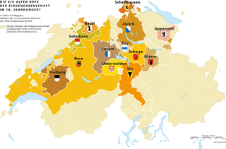
Deutsch: Die 13 «Alten Orte» (alte Kantone) der schweizerischen Eidgenossenschaft und ihr direkt beherrschtes Territorium im 18. Jahrhundert |
|
| তারিখ | 3.5.2007 | |
| উৎস | নিজের কাজ | |
| লেখক | Marco Zanoli (sidonius 19:14, 3 May 2007 (UTC)) | |
| অনুমতি (এ ফাইলের পুনঃব্যবহার) |
|
|
| অন্যান্য সংস্করণ |
|


|
This historical map image could be re-created using vector graphics as an SVG file. This has several advantages; see Commons:Media for cleanup for more information. If an SVG form of this image is available, please upload it and afterwards replace this template with
{{vector version available|new image name}}.
It is recommended to name the SVG file “Karte 13 Alte Orte.svg”—then the template Vector version available (or Vva) does not need the new image name parameter. |
ফাইলের ইতিহাস
যেকোনো তারিখ/সময়ে ক্লিক করে দেখুন ফাইলটি তখন কী অবস্থায় ছিল।
| তারিখ/সময় | সংক্ষেপচিত্র | মাত্রা | ব্যবহারকারী | মন্তব্য | |
|---|---|---|---|---|---|
| বর্তমান | ০৮:৫৯, ৮ মার্চ ২০২২ | | ২,৫০০ × ১,৬৫২ (৫১২ কিলোবাইট) | Sidonius | minor adjustements, higher resolution |
| ০৪:৫১, ৪ জুলাই ২০১০ |  | ১,২০০ × ৭৬১ (২৩৬ কিলোবাইট) | DcoetzeeBot | Remove watermark, add author and license data to image metadata, decrease filesize with pngcrush | |
| ১৩:৩৫, ৩ মে ২০০৭ |  | ১,২০০ × ৭৬১ (২৩৫ কিলোবাইট) | Sidonius | {{Information |Description={{de|Die 13 «Alten Orte» (alte Kantone) der schweizerischen Eidgenossenschaft und ihr direkt beherrschtes Territorium im 18. Jahrhundert}} |Source=own work |Date=3.5.2007 |Author= |Permission={{A |
সংযোগসমূহ
নিচের পৃষ্ঠা(গুলো) থেকে এই ছবিতে সংযোগ আছে:
ফাইলের বৈশ্বিক ব্যবহার
নিচের অন্যান্য উইকিগুলো এই ফাইলটি ব্যবহার করে:
- als.wikipedia.org-এ ব্যবহার
- cs.wikipedia.org-এ ব্যবহার
- de.wikipedia.org-এ ব্যবহার
- en.wikipedia.org-এ ব্যবহার
- eo.wikipedia.org-এ ব্যবহার
- et.wikipedia.org-এ ব্যবহার
- fi.wikipedia.org-এ ব্যবহার
- fr.wikipedia.org-এ ব্যবহার
- gl.wikipedia.org-এ ব্যবহার
- he.wikipedia.org-এ ব্যবহার
- hy.wikipedia.org-এ ব্যবহার
- ilo.wikipedia.org-এ ব্যবহার
- it.wikipedia.org-এ ব্যবহার
- ka.wikipedia.org-এ ব্যবহার
- ko.wikipedia.org-এ ব্যবহার
- nl.wikipedia.org-এ ব্যবহার
- sl.wikipedia.org-এ ব্যবহার
- sv.wikipedia.org-এ ব্যবহার
- uk.wikipedia.org-এ ব্যবহার
- zh.wikipedia.org-এ ব্যবহার