
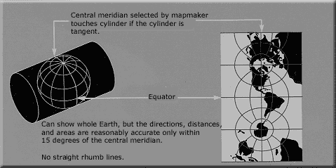
চিত্র:Usgs map traverse mercator.PNG
এর চেয়ে বেশি রেজোলিউশন লভ্য নয়।
Usgs_map_traverse_mercator.PNG (৪৭৯ × ২৩৯ পিক্সেল, ফাইলের আকার: ১৮ কিলোবাইট, এমআইএমই ধরন: image/png)
| এই ফাইলটি উইকিমিডিয়া কমন্স থেকে নেওয়া। সেখানের বর্ণনা পাতার বিস্তারিত নিম্নে দেখানো হলো। (সম্পাদনা)
|

|
This map image could be re-created using vector graphics as an SVG file. This has several advantages; see Commons:Media for cleanup for more information. If an SVG form of this image is available, please upload it and afterwards replace this template with
{{vector version available|new image name}}.
It is recommended to name the SVG file “Usgs map traverse mercator.svg”—then the template Vector version available (or Vva) does not need the new image name parameter. |
সারাংশ
লাইসেন্স প্রদান
This image is in the public domain in the United States because it only contains materials that originally came from the United States Geological Survey, an agency of the United States Department of the Interior. For more information, see the official USGS copyright policy.
|
ফাইলের ইতিহাস
যেকোনো তারিখ/সময়ে ক্লিক করে দেখুন ফাইলটি তখন কী অবস্থায় ছিল।
| তারিখ/সময় | সংক্ষেপচিত্র | মাত্রা | ব্যবহারকারী | মন্তব্য | |
|---|---|---|---|---|---|
| বর্তমান | ১৩:১৮, ৩ মার্চ ২০১০ | | ৪৭৯ × ২৩৯ (১৮ কিলোবাইট) | Peter Mercator | Corrected two spelling mistakes. (Thanks to daan Strebe) |
| ০৭:৩৮, ৬ এপ্রিল ২০০৭ |  | ৪৭৯ × ২৩৯ (১৯ কিলোবাইট) | The Anome | {{ShouldBeSVG}} == Summary == [http://erg.usgs.gov/isb/pubs/MapProjections/projections.html World map projection] == Licensing == {{PD-USGov-USGS}} <!--Categories--> Category:USGS projections | |
| ১৪:২৭, ১৭ ফেব্রুয়ারি ২০০৫ |  | ৩৬৫ × ১৭৫ (৩১ কিলোবাইট) | Quadell | World map projection ([http://erg.usgs.gov/isb/pubs/MapProjections/projections.html source)]{{PD-USGov-USGS}}Category:World mapsCategory:Map projectionsCategory:Map diagrams |
সংযোগসমূহ
এই ফাইল ব্যবহার করে এমন কোনো পাতা নেই।
ফাইলের বৈশ্বিক ব্যবহার
নিচের অন্যান্য উইকিগুলো এই ফাইলটি ব্যবহার করে:
- ast.wikipedia.org-এ ব্যবহার
- ca.wikipedia.org-এ ব্যবহার
- en.wikipedia.org-এ ব্যবহার
- es.wikipedia.org-এ ব্যবহার
- fi.wikipedia.org-এ ব্যবহার
- fr.wikipedia.org-এ ব্যবহার
- it.wikipedia.org-এ ব্যবহার
- ja.wikipedia.org-এ ব্যবহার
- ka.wikipedia.org-এ ব্যবহার
- ko.wikipedia.org-এ ব্যবহার
- lt.wikipedia.org-এ ব্যবহার
- mk.wikipedia.org-এ ব্যবহার
- no.wikipedia.org-এ ব্যবহার
- sr.wikipedia.org-এ ব্যবহার
- zh.wikipedia.org-এ ব্যবহার