
চিত্র:South asia.jpg
এর চেয়ে বেশি রেজোলিউশন লভ্য নয়।
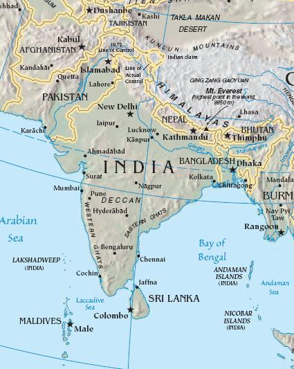
South_asia.jpg (৪২৫ × ৫৩৩ পিক্সেল, ফাইলের আকার: ৫২ কিলোবাইট, এমআইএমই ধরন: image/jpeg)
| এই ফাইলটি উইকিমিডিয়া কমন্স থেকে নেওয়া। সেখানের বর্ণনা পাতার বিস্তারিত নিম্নে দেখানো হলো। (সম্পাদনা)
|
সারাংশ
| বিবরণ |
Import from File:South asia.jpg 26 July 2008 English: The image is cropped from en:Image:Sino-Indian Geography.png, created and published by the en:Central Intelligence Agency of the en:United States of America in en:2004.
NoteThis map represents the en:line of control in en:Kashmir as the international border between the en:Republic of India and en:Islamic Republic of Pakistan, a position considered unacceptable to either party. |
| উৎস | CIA World Factbook |
| লেখক | CIA |

|
This map image could be re-created using vector graphics as an SVG file. This has several advantages; see Commons:Media for cleanup for more information. If an SVG form of this image is available, please upload it and afterwards replace this template with
{{vector version available|new image name}}.
It is recommended to name the SVG file “South asia.svg”—then the template Vector version available (or Vva) does not need the new image name parameter. |


লাইসেন্স প্রদান
এই ছবিটি পাবলিক ডোমেইনে কারণ এটিতে উপকরণ রয়েছে যা মূলত মার্কিন যুক্তরাষ্ট্রের কেন্দ্রীয় গোয়েন্দা সংস্থার ওয়ার্ল্ড ফ্যাক্টবুক থেকে এসেছে।
|
 |
মূল আপলোড লগ
মূল বিবরণ পাতাটি এখানে ছিল। নিম্নলিখিত সকল ব্যবহারকারীর নাম en.wikipedia-এ উল্লেখ করা ছিল।
- 2003-10-28 08:22 Mkweise 421×541×8 (88052 bytes) cropped from PD image
ফাইলের ইতিহাস
যেকোনো তারিখ/সময়ে ক্লিক করে দেখুন ফাইলটি তখন কী অবস্থায় ছিল।
| তারিখ/সময় | সংক্ষেপচিত্র | মাত্রা | ব্যবহারকারী | মন্তব্য | |
|---|---|---|---|---|---|
| বর্তমান | ১৬:৫৯, ৬ আগস্ট ২০০৮ | | ৪২৫ × ৫৩৩ (৫২ কিলোবাইট) | Deepak~commonswiki | |
| ০০:৪৮, ২৭ জুলাই ২০০৮ |  | ৪২১ × ৫৪১ (৮৬ কিলোবাইট) | File Upload Bot (Magnus Manske) | {{BotMoveToCommons|en.wikipedia}} {{Information |Description={{en|<small>The image is cropped from en::Image:Sino-Indian Geography.png, created and published by the en:Central Intelligence Agency of the en:United States of America in [[:en |
সংযোগসমূহ
এই ফাইল ব্যবহার করে এমন কোনো পাতা নেই।
ফাইলের বৈশ্বিক ব্যবহার
নিচের অন্যান্য উইকিগুলো এই ফাইলটি ব্যবহার করে:
- ace.wikipedia.org-এ ব্যবহার
- ar.wikipedia.org-এ ব্যবহার
- ast.wikipedia.org-এ ব্যবহার
- bg.wikipedia.org-এ ব্যবহার
- bs.wikipedia.org-এ ব্যবহার
- cy.wikipedia.org-এ ব্যবহার
- en.wikipedia.org-এ ব্যবহার
- es.wikipedia.org-এ ব্যবহার
- id.wikipedia.org-এ ব্যবহার
- incubator.wikimedia.org-এ ব্যবহার
- jv.wikipedia.org-এ ব্যবহার
- kn.wikipedia.org-এ ব্যবহার
- la.wikipedia.org-এ ব্যবহার
- ml.wikipedia.org-এ ব্যবহার
- ms.wikipedia.org-এ ব্যবহার
- pam.wikipedia.org-এ ব্যবহার
- pl.wiktionary.org-এ ব্যবহার
- pnb.wikipedia.org-এ ব্যবহার
- rmy.wikipedia.org-এ ব্যবহার
- ru.wikipedia.org-এ ব্যবহার
- sh.wikipedia.org-এ ব্যবহার
- simple.wikipedia.org-এ ব্যবহার
- sr.wikipedia.org-এ ব্যবহার
- sv.wikipedia.org-এ ব্যবহার
- ta.wikipedia.org-এ ব্যবহার
- te.wikipedia.org-এ ব্যবহার
- tl.wikipedia.org-এ ব্যবহার
- tr.wikipedia.org-এ ব্যবহার
- tr.wiktionary.org-এ ব্যবহার
- war.wikipedia.org-এ ব্যবহার
- www.wikidata.org-এ ব্যবহার
- zh.wikipedia.org-এ ব্যবহার
এই ফাইলের অন্যান্য বৈশ্বিক ব্যবহার দেখুন।