
চিত্র:PtolemyWorldMap.jpg

এই প্রাকদর্শনের আকার: ৮০০ × ৫৪৭ পিক্সেল। অন্যান্য আকারসমূহ: ৩২০ × ২১৯ পিক্সেল | ৬৪০ × ৪৩৮ পিক্সেল | ১,০২৪ × ৭০০ পিক্সেল | ১,২৮০ × ৮৭৬ পিক্সেল | ১,৫০০ × ১,০২৬ পিক্সেল।
পূর্ণ রেজোলিউশন (১,৫০০ × ১,০২৬ পিক্সেল, ফাইলের আকার: ৮৬৭ কিলোবাইট, এমআইএমই ধরন: image/jpeg)
| এই ফাইলটি উইকিমিডিয়া কমন্স থেকে নেওয়া। সেখানের বর্ণনা পাতার বিস্তারিত নিম্নে দেখানো হলো। (সম্পাদনা)
|
সারাংশ
| বিবরণ |
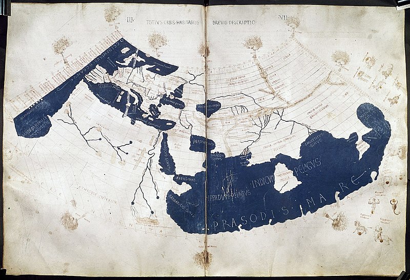
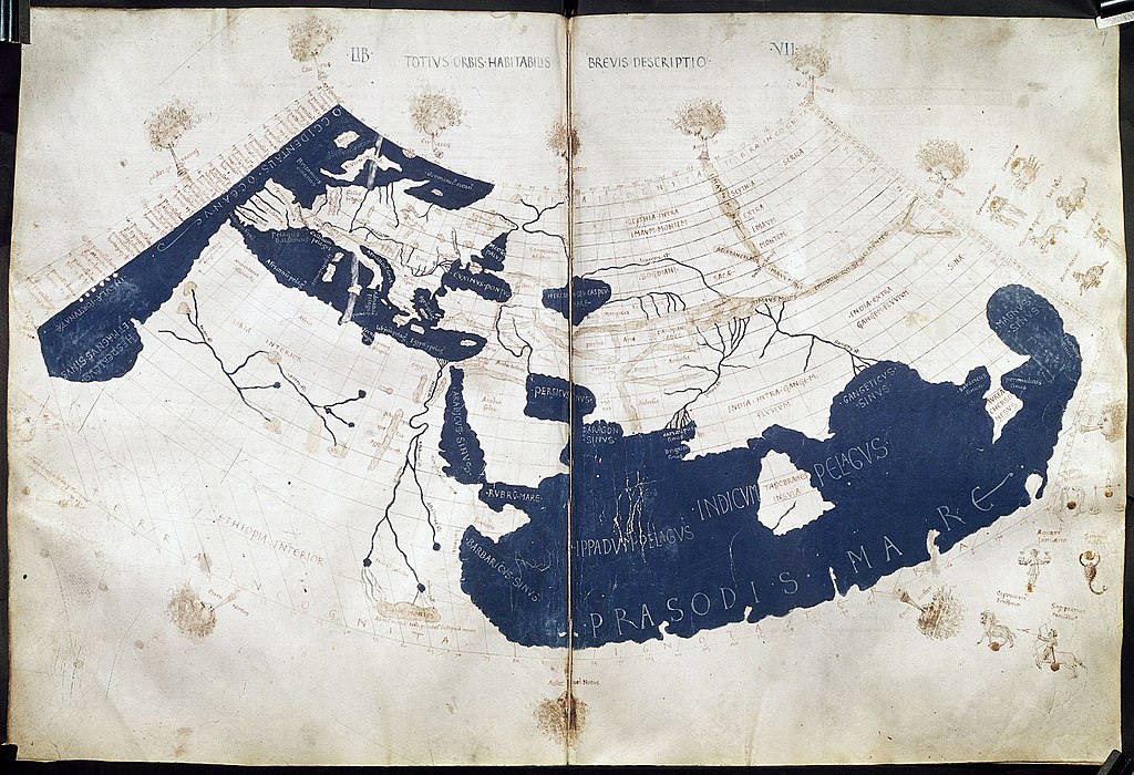
English: A mid-15th century Florentine map of the world based on Jacobus Angelus's 1406 Latin translation of Maximus Planudes's late-13th century rediscovered Greek manuscripts of Ptolemy's 2nd-century Geography. Ptolemy's 1st (modified conic) projection. 中文:《托勒密世界地图》,原为克劳狄乌斯·托勒密所著《地理学》书中所附的多幅地图,后来由君士坦丁堡的希腊修士马克西姆·普拉努德斯等人重新编集,并由14世纪的意大利学者雅各布·安格鲁斯译为拉丁文。该地图15世纪中期在佛罗伦萨出版。 |
| তারিখ | ad 1450–1475 |
| উৎস | Ptolemy's Geography (Harleian MS 7182, ff 58–59) |
| লেখক | Credited to Francesco di Antonio del Chierico |
লাইসেন্স প্রদান
|
This is a faithful photographic reproduction of a two-dimensional, public domain work of art. The work of art itself is in the public domain for the following reason:
The official position taken by the Wikimedia Foundation is that "faithful reproductions of two-dimensional public domain works of art are public domain".
This photographic reproduction is therefore also considered to be in the public domain in the United States. In other jurisdictions, re-use of this content may be restricted; see Reuse of PD-Art photographs for details. | ||||
| Annotations | This image is annotated: View the annotations at Commons |
ফাইলের ইতিহাস
যেকোনো তারিখ/সময়ে ক্লিক করে দেখুন ফাইলটি তখন কী অবস্থায় ছিল।
| তারিখ/সময় | সংক্ষেপচিত্র | মাত্রা | ব্যবহারকারী | মন্তব্য | |
|---|---|---|---|---|---|
| বর্তমান | ২৩:০২, ২৭ জুলাই ২০১৪ | | ১,৫০০ × ১,০২৬ (৮৬৭ কিলোবাইট) | Khamar | Larger scan from British Library retreived 2014-7-27 http://www.bl.uk/catalogues/illuminatedmanuscripts/ILLUMIN.ASP?Size=mid&IllID=28894 which has been slightly sharpened. Text clarity is improved in this version and the overall tint is less yellow. |
| ১২:৪৫, ২৭ নভেম্বর ২০০৫ |  | ১,৩৪৪ × ৯১৫ (৮১০ কিলোবাইট) | Alfio | Bigger version | |
| ১১:০০, ২০ জুন ২০০৫ |  | ৮০০ × ৫৪৫ (১০৭ কিলোবাইট) | Horatius | Ptolemy's 150 CE World Map (redrawn in the 15th century). The British Library Harley MS 7182, ff 58v-59 {{PD-art}} |
সংযোগসমূহ
নিচের পৃষ্ঠা(গুলো) থেকে এই ছবিতে সংযোগ আছে:
ফাইলের বৈশ্বিক ব্যবহার
নিচের অন্যান্য উইকিগুলো এই ফাইলটি ব্যবহার করে:
- ang.wikipedia.org-এ ব্যবহার
- ar.wikipedia.org-এ ব্যবহার
- arz.wikipedia.org-এ ব্যবহার
- az.wikipedia.org-এ ব্যবহার
- ba.wikipedia.org-এ ব্যবহার
- bg.wikipedia.org-এ ব্যবহার
- br.wikipedia.org-এ ব্যবহার
- bs.wikipedia.org-এ ব্যবহার
- ca.wikipedia.org-এ ব্যবহার
- ce.wikipedia.org-এ ব্যবহার
- cs.wikipedia.org-এ ব্যবহার
- cv.wikipedia.org-এ ব্যবহার
- da.wikipedia.org-এ ব্যবহার
- de.wikipedia.org-এ ব্যবহার
- el.wikipedia.org-এ ব্যবহার
- en.wikipedia.org-এ ব্যবহার
এই ফাইলের অন্যান্য বৈশ্বিক ব্যবহার দেখুন।