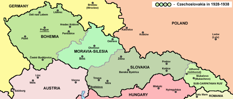
চিত্র:Czechoslovakia01.png

এই প্রাকদর্শনের আকার: ৮০০ × ৩৪০ পিক্সেল। অন্যান্য আকারসমূহ: ৩২০ × ১৩৬ পিক্সেল | ১,১০০ × ৪৬৮ পিক্সেল।
পূর্ণ রেজোলিউশন (১,১০০ × ৪৬৮ পিক্সেল, ফাইলের আকার: ৬৩ কিলোবাইট, এমআইএমই ধরন: image/png)
ফাইলের ইতিহাস
যেকোনো তারিখ/সময়ে ক্লিক করে দেখুন ফাইলটি তখন কী অবস্থায় ছিল।
| তারিখ/সময় | সংক্ষেপচিত্র | মাত্রা | ব্যবহারকারী | মন্তব্য | |
|---|---|---|---|---|---|
| বর্তমান | ১৪:৪৮, ১২ জুলাই ২০২২ |  | ১,১০০ × ৪৬৮ (৬৩ কিলোবাইট) | Sebastian Wallroth | cropped |
| ১০:৫৪, ১৯ মে ২০১১ |  | ১,১২৮ × ৫১৩ (৬৩ কিলোবাইট) | PANONIAN | minor change, marked provincial capitals | |
| ০৯:৫৩, ১৭ মে ২০১১ |  | ১,১২৮ × ৫১৩ (৬২ কিলোবাইট) | PANONIAN | Reverted to version as of 10:38, 24 April 2011 - because this is map of Czechoslovakia and it was capital of Czechoslovakia | |
| ০৫:০৭, ১৭ মে ২০১১ |  | ১,১২৮ × ৫১৩ (৫৫ কিলোবাইট) | Millenium187 | Why was Prague underlined and Vienna, Brno, Bratislava and other capital cities were not? -- corrected | |
| ১০:৩৮, ২৪ এপ্রিল ২০১১ |  | ১,১২৮ × ৫১৩ (৬২ কিলোবাইট) | PANONIAN | few corrections | |
| ১১:৩১, ২৩ এপ্রিল ২০১১ |  | ১,১২৮ × ৫০৯ (৬১ কিলোবাইট) | PANONIAN | improved version | |
| ২০:৫৮, ২০ ডিসেম্বর ২০০৮ |  | ১,১০০ × ৪৯৭ (৭৮ কিলোবাইট) | Kirk979 | {{Information |Description= |Source= |Date= |Author= |Permission= |other_versions= }} | |
| ১৬:১১, ২৮ ডিসেম্বর ২০০৬ |  | ১,১০০ × ৪৯৭ (৯০ কিলোবাইট) | Electionworld | {{ew|en|PANONIAN}} Map of {{link|Czechoslovakia}} (self made) Note: The provinces shown on the map were introduced by Act No. 125/1927 Zb. and became effective in 1928. {{PD-self}} Category:Maps of Czechoslovakia Category:Maps of Czech history |
সংযোগসমূহ
নিচের পৃষ্ঠা(গুলো) থেকে এই ছবিতে সংযোগ আছে:
ফাইলের বৈশ্বিক ব্যবহার
নিচের অন্যান্য উইকিগুলো এই ফাইলটি ব্যবহার করে:
- af.wikipedia.org-এ ব্যবহার
- als.wikipedia.org-এ ব্যবহার
- ang.wikipedia.org-এ ব্যবহার
- an.wikipedia.org-এ ব্যবহার
- ar.wikipedia.org-এ ব্যবহার
- arz.wikipedia.org-এ ব্যবহার
- azb.wikipedia.org-এ ব্যবহার
- az.wikipedia.org-এ ব্যবহার
- ba.wikipedia.org-এ ব্যবহার
- bcl.wikipedia.org-এ ব্যবহার
- be-tarask.wikipedia.org-এ ব্যবহার
- be.wikipedia.org-এ ব্যবহার
- bg.wikipedia.org-এ ব্যবহার
- br.wikipedia.org-এ ব্যবহার
- ca.wikipedia.org-এ ব্যবহার
- cs.wikipedia.org-এ ব্যবহার
- cv.wikipedia.org-এ ব্যবহার
- cy.wikipedia.org-এ ব্যবহার
- de.wikipedia.org-এ ব্যবহার
- diq.wikipedia.org-এ ব্যবহার
- dsb.wikipedia.org-এ ব্যবহার
- el.wikipedia.org-এ ব্যবহার
- en.wikipedia.org-এ ব্যবহার
এই ফাইলের অন্যান্য বৈশ্বিক ব্যবহার দেখুন।


