
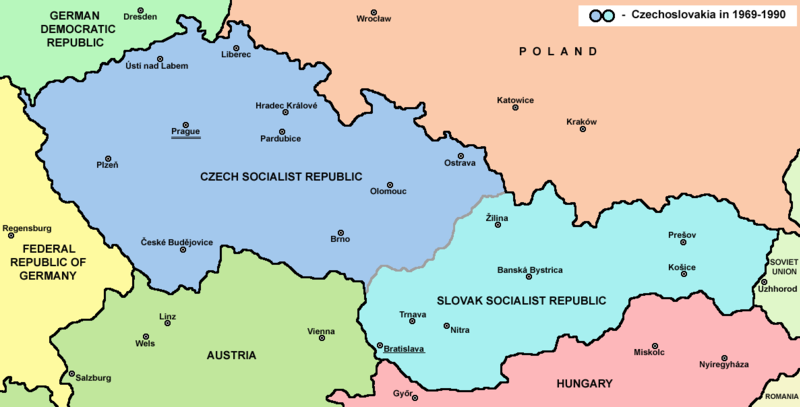
চিত্র:Czechoslovakia.png

এই প্রাকদর্শনের আকার: ৮০০ × ৪০৭ পিক্সেল। অন্যান্য আকারসমূহ: ৩২০ × ১৬৩ পিক্সেল | ৬৪০ × ৩২৫ পিক্সেল | ১,১৮৮ × ৬০৪ পিক্সেল।
পূর্ণ রেজোলিউশন (১,১৮৮ × ৬০৪ পিক্সেল, ফাইলের আকার: ৬৯ কিলোবাইট, এমআইএমই ধরন: image/png)
| এই ফাইলটি উইকিমিডিয়া কমন্স থেকে নেওয়া। সেখানের বর্ণনা পাতার বিস্তারিত নিম্নে দেখানো হলো। (সম্পাদনা)
|

|
This historical map image could be re-created using vector graphics as an SVG file. This has several advantages; see Commons:Media for cleanup for more information. If an SVG form of this image is available, please upload it and afterwards replace this template with
{{vector version available|new image name}}.
It is recommended to name the SVG file “Czechoslovakia.svg”—then the template Vector version available (or Vva) does not need the new image name parameter. |
সারাংশ
| বিবরণ |
English: Map of Czechoslovakia in 1969-1990 |
| উৎস | নিজের কাজ |
| লেখক | PANONIAN |
| অন্যান্য সংস্করণ | এই ফাইলের উপজাত কর্মসমূহ: |


লাইসেন্স প্রদান
| |
এই কাজের প্রণেতা PANONIAN উইকিমিডিয়া কমন্স প্রকল্পের কাজটি পাবলিক ডোমেইনে প্রকাশ করেছেন। এটি বিশ্বব্যাপী প্রযোজ্য হবে। যে ক্ষেত্রে এটি আইনত সম্ভব নয়: |
References
Main reference:
- Map is created according to this external source: http://www.tcnj.edu/~guhr2/images/czechoslovakia.jpg আর্কাইভকৃত অনুলিপি at the Wayback Machine
Secondary references with similar maps:
- http://1.bp.blogspot.com/_Qe1wgxDiEdU/TGti_qWpeYI/AAAAAAAABo0/sSqAfIpQMuU/s1600/1213M_CS.gif
- https://jspivey.wikispaces.com/file/view/T010895A.gif/34419939/T010895A.gif
- http://media.web.britannica.com/eb-media/84/105684-050-0D8412E3.gif আর্কাইভকৃত অনুলিপি at the Wayback Machine
- http://www.gatheringofisrael.com/atlas/europe/slavic/CS_prague.gif
- http://collections.lib.uwm.edu/agsmap/images/lg/DSCN1455.jpg[dead link]
- http://leccos.com/pics/pic/ceskoslovensko-_mapa_1950.jpg আর্কাইভকৃত অনুলিপি at the Wayback Machine
- http://www.math.sk/knor/GIF/mapa.gif
- http://ckpaji.sweb.cz/ceskoslovensko.jpg আর্কাইভকৃত অনুলিপি at the Wayback Machine
- http://www.power.szm.com/historia/mapa_TV_vysielacov_1978.jpg
Secondary references about Geo-political situation - published sources:
- The Times History of Europe, Times Books, London, 2002.
- Richard Overy, The Times History of the 20th Century, Times Books, London, 2004.
- The Times Atlas svjetske povijesti, Cankarjeva založba, Ljubljana - Zagreb, 1986.
- Istorijski atlas, Geokarta, Beograd, 1999.
- Školski istorijski atlas, Zavod za izdavanje udžbenika SR Srbije, Beograd, 1970.
- Povijesni atlas, Učila - Zagreb, Zagreb, 1971.
- Povijesni atlas za osnovnu školu, Kartografija - Tlos, Zagreb, 1975.
- Denis Šehić - Demir Šehić, Istorijski atlas sveta, Beograd, 2007.
Secondary reference about sizable cities:
|
|
This map image could be re-created using vector graphics as an SVG file. This has several advantages; see Commons:Media for cleanup for more information. If an SVG form of this image is available, please upload it and afterwards replace this template with
{{vector version available|new image name}}.
It is recommended to name the SVG file “Czechoslovakia.svg”—then the template Vector version available (or Vva) does not need the new image name parameter. |
এই ফাইলটির উৎপাদন, সম্পাদনা বা ভাগ করা উইকিমিডিয়া জার্মানির কমিউনিটি বাজেট দ্বারা সমর্থিত ছিল। উইকিমিডিয়া জার্মানি দ্বারা সমর্থিত সংশ্লিষ্ট সব ফাইলের জন্য, দয়া করে বিষয়শ্রেণী উইকিমিডিয়া জার্মানি কর্তৃক সমর্থিত দেখুন। |
ফাইলের ইতিহাস
যেকোনো তারিখ/সময়ে ক্লিক করে দেখুন ফাইলটি তখন কী অবস্থায় ছিল।
| তারিখ/সময় | সংক্ষেপচিত্র | মাত্রা | ব্যবহারকারী | মন্তব্য | |
|---|---|---|---|---|---|
| বর্তমান | ১৪:৪৫, ১২ জুলাই ২০২২ | | ১,১৮৮ × ৬০৪ (৬৯ কিলোবাইট) | Sebastian Wallroth | CROPPED |
| ১৭:৩৮, ১২ ফেব্রুয়ারি ২০১৭ |  | ১,২২১ × ৬৫২ (৬৯ কিলোবাইট) | PANONIAN | Reverted to version as of 11:00, 24 April 2011 (UTC) - why you uploading polish version over english one? upload polish version under different filename | |
| ১৫:১৮, ৯ ফেব্রুয়ারি ২০১৭ |  | ১,২২১ × ৬৫২ (৫৭ কিলোবাইট) | Kelvin | Reverted to version as of 15:13, 9 February 2017 (UTC) | |
| ১৫:১৭, ৯ ফেব্রুয়ারি ২০১৭ |  | ১,২২১ × ৬৫২ (৬৯ কিলোবাইট) | Kelvin | Reverted to version as of 11:00, 24 April 2011 (UTC) | |
| ১৫:১৩, ৯ ফেব্রুয়ারি ২০১৭ |  | ১,২২১ × ৬৫২ (৫৭ কিলোবাইট) | Kelvin | Polish names of countries /Polskie określenia krajów | |
| ১১:০০, ২৪ এপ্রিল ২০১১ |  | ১,২২১ × ৬৫২ (৬৯ কিলোবাইট) | PANONIAN | correction | |
| ১০:২৭, ২৩ এপ্রিল ২০১১ |  | ১,২২১ × ৬৫২ (৬৯ কিলোবাইট) | PANONIAN | improved version | |
| ২৩:৩১, ১০ ডিসেম্বর ২০০৬ |  | ১,২০০ × ৬২৪ (১৯ কিলোবাইট) | Severino666~commonswiki | Map of Czechoslovakia (self made) Category:Maps of Czechoslovakia Category:Maps of Czech history Category:Maps of the history of Slovakia Category:Maps of the history of Central Europe {{PD}} |
সংযোগসমূহ
নিচের পৃষ্ঠা(গুলো) থেকে এই ছবিতে সংযোগ আছে:
ফাইলের বৈশ্বিক ব্যবহার
নিচের অন্যান্য উইকিগুলো এই ফাইলটি ব্যবহার করে:
- ang.wikipedia.org-এ ব্যবহার
- an.wikipedia.org-এ ব্যবহার
- ar.wikipedia.org-এ ব্যবহার
- azb.wikipedia.org-এ ব্যবহার
- az.wikipedia.org-এ ব্যবহার
- ba.wikipedia.org-এ ব্যবহার
- bcl.wikipedia.org-এ ব্যবহার
- be-tarask.wikipedia.org-এ ব্যবহার
- be.wikipedia.org-এ ব্যবহার
- bg.wikipedia.org-এ ব্যবহার
- br.wikipedia.org-এ ব্যবহার
- bs.wikipedia.org-এ ব্যবহার
- ca.wikipedia.org-এ ব্যবহার
- cv.wikipedia.org-এ ব্যবহার
- da.wikipedia.org-এ ব্যবহার
- de.wikipedia.org-এ ব্যবহার
- dsb.wikipedia.org-এ ব্যবহার
- el.wikipedia.org-এ ব্যবহার
- en.wikipedia.org-এ ব্যবহার
- Czechoslovakia
- History of Slovakia
- History of Czechoslovakia (1948–1989)
- History of Czechoslovakia (1989–1992)
- Economy of communist Czechoslovakia
- History of Czechoslovakia
- Dissolution of Czechoslovakia
- Czechoslovak Socialist Republic
- Portal:Slovakia
- She Grazed Horses on Concrete
- Rugby union in Czechoslovakia
- User:Chickstarr404/Gather lists/20626 – Life under the USSR totalitarian control and its demise
এই ফাইলের অন্যান্য বৈশ্বিক ব্যবহার দেখুন।